Background
Forecasting Environmental Conditions Throughout the Chesapeake Bay
The Chesapeake Bay Environmental Forecast System (CBEFS) uses a computer model to forecast the environmental conditions throughout Chesapeake Bay every day, including salinity and water temperature, along with dissolved oxygen and acidification. Low dissolved oxygen and changing acidification can have harmful impacts on the Chesapeake Bay ecosystem.
“Dead zones”—areas with too little oxygen for most marine life—can occur when nutrients from fertilizers, sewage, and other sources feed algal blooms. When these algae die and sink, their decomposition takes up dissolved oxygen from the water. Scientists refer to these oxygen-poor waters as hypoxic, and to water with no measurable dissolved oxygen as anoxic. Hypoxia is typically most pronounced in deeper waters, and during summer. Learn more about how and why dead zones form.
Because even small decreases in dissolved oxygen can significantly impact fish and other marine animals, researchers at the Virginia Institute of Marine Science and elsewhere are working to develop and refine computer models to accurately predict when and where hypoxia may develop. Their goal is to help anglers and other Bay enthusiasts better plan their day-to-day activities.
Another stressor to the Chesapeake Bay is acidification that results from increased CO2 in the water. Acidification can have harmful affects on shellfish, such as oysters, throughout the Bay. Researchers are working to improve computer models of acidification to be able to better predict the short- and long-term effects on the Chesapeake Bay.
The Chesapeake Bay Environmental Forecast System (CBEFS) uses a three-dimensional (3-D), numerical model to simulate salinity, temperature, dissolved-oxygen and acidification in the waters of Chesapeake Bay. As of April 2021, the 3-D forecast model is an enhanced high-resolution version of a previous model of the Bay, providing the highest quality forecasts of conditions through the Chesapeake Bay and tributaries. The forecast model simulates multiple conditions.
- Today's Forecast: conditions throughout the Bay today,
- Tomorrow's Forecast: conditions throughout the Bay tomorrow,
- 5-Day forecast: conditions throughout the Bay in 5 days,
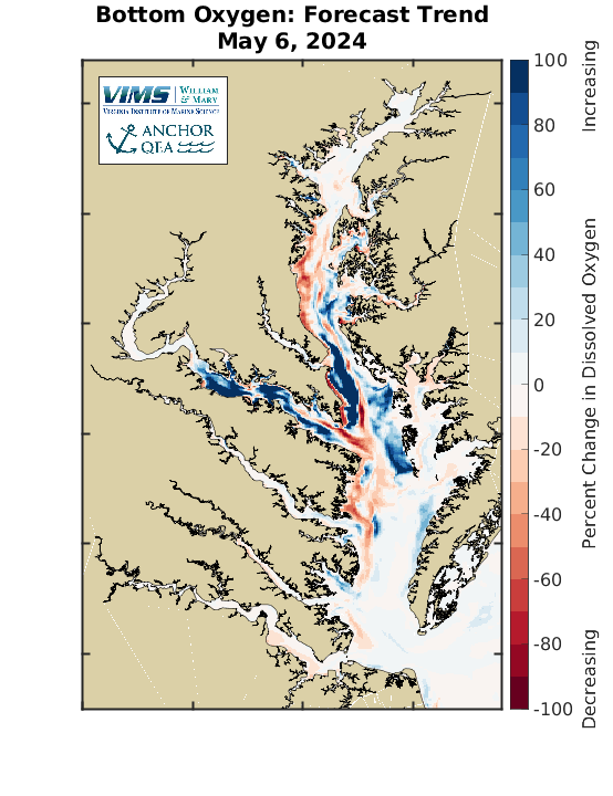
- Forecast Trend: change over 5 days, and
- Relative to Historical Conditions: how conditions in the Bay relate to today's average conditions from 1986 to the present
The 3-D model is forced by weather (winds, air temperature, etc.) provided by NOAA and river input provided by stream gauges operated by the U.S. Geological Survey (USGS). The USGS gauge data is scaled in the forecast model to better represent the total freshwater inflows to the Bay, which improves the salinity and dissolved oxygen forecasts. Terrestrial nutrient inputs are specified using Artificial Neural Network models based on the Chesapeake Bay Program watershed model. The 3-D model has 20 layers in the vertical and a horizontal resolution of approximately 600 meters (2000 feet), resulting in 1.2 million 3-D grid cells in the Bay, tributaries, and coastal ocean. A hydrodynamic component calculates temperature, salinity, and water transport. The model also includes a complex biogeochemistry component that simulates the growth and decay of microscopic plants throughout the Bay, and the associated affects on dissolved oxygen and acidification.
For more information on the model and its development, or for data requests, contact VIMS professor [[v|marjy,Marjy Friedrichs]], the Principal Investigator of the Biogeochemical Circulation Ocean Modeling laboratory.
|
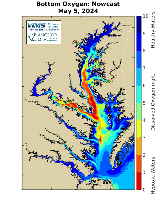
Example Dissolved Oxygen Nowcast
|
Example Dissolved Oxygen Trend
|