Whatare the permit types, applications, and required information?
Permits Types
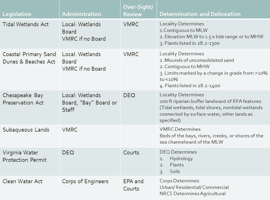
There are two categories of permits used to review and authorize activities in Virginia's tidal wetlands, beach and dunes, and/or subaqueous lands. Certain activities that are anticipated to have minor adverse impacts can qualify for one of three general permits issued by the Virginia Marine Resource Commission. The general permits expedite the review process and do not require a public hearing. Activities that do not qualify for a general permit are reviewed as an individual permit. In either case, one permit application is used by all regulatory and advisory agencies.
Individual Permits
Each applicable regulatory agency conducts an independent review and issues a permit for their jurisdiction. The table shows which agencies have permit authority for tidal shorelines in Virginia. See Conduct a Hearing for a description of the permit review and approval process.
General Permits
VMRC has several general permits for activities along the shoreline and on submerged lands.
The most relevant of these permits for Wetland Boards are:
Living Shoreline Group 2 General Permit – permit for sand fill, fiber logs, fiber mats, shell bags, riprap, woven containment bags and temporary grazing protection in tidal wetlands, beaches and submerged lands
Joint Permit Application (JPA)
One application is used to request all approvals for proposed impacts to tidal and non-tidal wetlands, dunes and beaches, and subaqueous resources from activities including construction, dredging, filling, or excavation. The Joint Permit Application is submitted to VMRC, which serves as a clearinghouse and distributes the joint application to the following permitting agencies for review.
The Tidewater JPA (the most commonly used JPA for tidal shoreline projects) is comprised of five parts. Applications are determined complete by the permitting authority. In order to be complete, the application must at a minimum include the following:
Part 1 – General Information
Information listed as required in the Tidal Wetlands Act (Wetlands Zoning Ordinance)
Information listed as required in the Tidal Wetlands Act
Applicant
The name and address of the applicant. If not the property owner, the name and address of the property owner must be provided.
Proposed Activity
A clear, detailed description of the proposed activities. This section is very important as it indicates to the reviewers what is being proposed. The description should be clear and detailed.
For shoreline erosion control activities, be sure to provide the following:
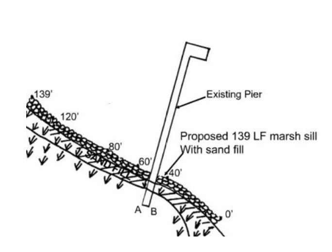
The type of proposed activity such as revetment, marsh sill, bulkhead, etc. and the linear feet (LF) of each proposed structure.
Indicate if the structure is new or a replacement structure. If it is a replacement structure, explain how; will the structure being replaced be removed or remain?
If a living shoreline is proposed, indicate weather sand nourishment and plantings are to be provided.
How the site will be accessed such as using an existing driveway, by water, or by an adjacent property owner’s property.
Will tree and/or grading be required? How large of an area (sq ft or acres) is proposed to be cleared?
Any other information necessary to clearly describe the activities proposed.
Example 1 – Sill
100 LF of class 1 stone sill is proposed channelward of an existing marsh. 35 cubic yards of sand nourishment is to be placed landward of the sill to augment the marsh. Approximately 250 square feet of sand area will be planted in spartina alterniflora (sprigs to be planted on 1 feet centers). No tree clearing or grading will be required. Access to the site will be through the driveway to the back yard.
Example 2 – Bulkhead
100 LF of vinyl bulkhead is proposed to replace the existing bulkhead that is to be removed. The existing bulkhead debris will be taken to the local landfill. Three trees along the shoreline will need to be removed for the project. Due to restrictions on land, the site will be accessed by a barge.
Example 3 – Revetment
100 LF of stone revetment is proposed. The eroded bank is to be graded back to a 2:1 slope, filter cloth is to be installed and the rock placed on the filter cloth. The toe of the revetment will be buried 2 feet below MLW. No trees will be removed. Grading area is 100 feet x 10 feet. Access to the site will be through the neighbor’s driveway and a section of my fence will be removed to enter the property. Neighbor has provided permission.
Plan View Map & Cross Section Views
See Part 4 – Project Drawings
Equipment and Access
Description of the type of equipment to be used and the means of equipment access to the activity site.
Adjacent Owners
Names and addresses of all adjacent land owners of record and known claimants of water rights in or adjacent to the property where the work is proposed.
Cost
An estimation of the cost of the project.
Project Purpose
The primary purpose of the project; Any secondary purposes of the project, including further projects.
Public Benefit
The public benefit to be derived from the proposed project.
Mitigation
A complete description of measures to be taken during and after the alteration to reduce detrimental offsite effects.
Expected Timeline
The completion date of the proposed work, project, or structure.
Suggested Information
Physical address of the property site with detailed directions to the site.
Additional Information
Such additional materials and documentation as the wetlands board may require.
Part 2 – Signatures
Applicant and/or property owner signature form
Adjacent property owner acknowledgement form(s)
Agent/ contractor authorization signature form
Part 3 – Appendices
Submit the appendices that are as applicable to your project:
A – Projects for Access (piers,etc)
B – Shoreline Stabilization (most commonly used for shoreline erosion control projects)
C – Crossings
D – Aquaculture Related Structures
Part 4 – Project Drawings
ALL applications shall include the following drawings (on 8.5" x 11" white paper):
Vicinity Map
A map showing the location of the project site.
There are many available on-line map sites, such as Google Maps, Google Earth, Map Quest, County/City Tax Maps and Parcel Viewers to help easily create a vicinity map to identify the location of the project.
To facilitate the review of a project, it is important that wetlands board staff, wetlands board members, and VMRC staff are able to easily locate the project site. The vicinity map should be clear as to the location of your project.
Plan View Drawing
(overhead, to scale or with dimensions clearly marked)
The example below shows a general overall plan view and a more detailed zoomed in plan view with benchmarks.
Name of Project
Example: Joe Smith's revetment project
North Arrow
North arrow correctly indicating where north is located in relation to the drawing.
Scale
The map needs to be drawn to an appropriate and uniform scale.
Waterway Name
The name of the immediate waterway where the project is proposed.
Existing Structures
All existing structures on the site such as houses, sheds, piers, fences, etc. shown and labeled as existing.
Proposed Structures
All proposed structures such as revetment, marsh sill, pier, etc. clearly identified on the plan and labeled with dimensions (linear feet - LF) as proposed.
Mean High Water (MHW) and Mean Low Water (MLW) Lines
MHW and MLW clearly delineated on the plan view drawing. MHW and MLW locations are one of the most important pieces of information on a plan. Their locations determine the permitting authorities’ jurisdictions (limits of territory where a permit may be required). There are several permitting authorities involved in a shoreline project and they each have different and sometimes overlapping jurisdictions.
Examples of MHW and MLW clearly delineated:
Wetlands and Impacts
Limits of wetlands on the project site clearly delineated on the plan view drawing. The square feet of impacts indicated on the plan.
Surface Waters and Impacts
All surface waters (i.e. rivers, creeks) on the project site clearly delineated on the plan view drawing. The limits of proposed impacts (in square feet or acres) to surface waters such as fill areas, riprap toe protection, and dredged areas should be provided on the plan.
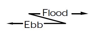
Ebb/Flood Direction
Indicate with arrows the ebb and flood direction of the tide. The ebb direction is the tidal flow going out to sea and flowing in of the tide is the flood direction.
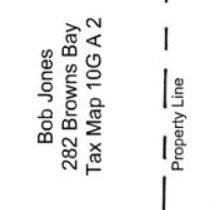
Property Lines and Adjacent Property Owner Information
Location of property lines; parcel identification of adjacent properties as well as name and address of adjacent property owners. This information is important since adjacent property owners must be legally notified of the project.
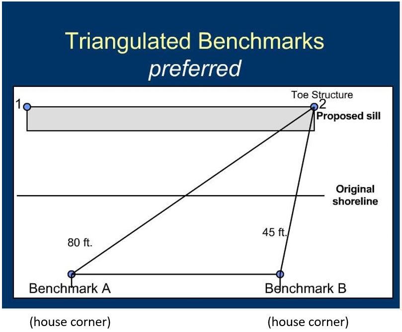
Benchmark Distances
Benchmarks are the distances measured between the “toe” (or most channelward location of a structure) and a permanent, identifiable, upland point (benchmark) such as a house corner, tree to remain, flag pole, fence post, etc.
Triangulated benchmarks are preferred, where a specific point at the toe of a structure is referenced back to two or more benchmark points.
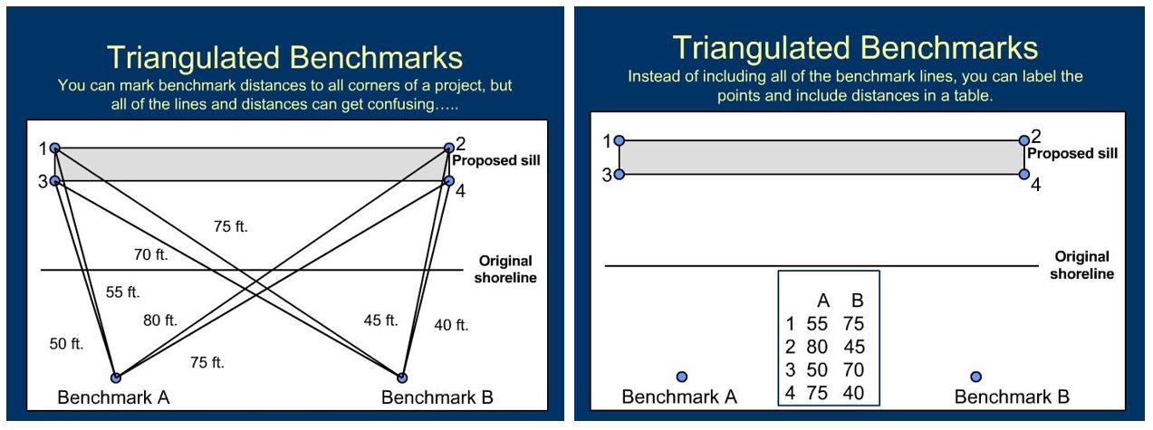
Benchmark lines along the entire project may make the drawing hard to read. In these cases, labeling the benchmarks and points, and including a table with the distances to points is acceptable.
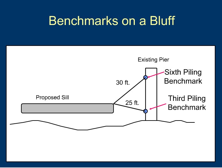
Benchmarks on a bluff can be a challenge. Use a permanent, fixed structure along the shoreline such as a pier, if present.
Cross Section View Drawing
(side-view, to scale or with dimensions clearly marked)
In addition to a Plan View Drawing, a Cross Section View Drawing(s) illustrating the shoreline and proposed modifications is required as part of the Joint Permit Application. The locations where cross section views are provided must be identified on the plan view drawing so that reviewers and others know where along the shoreline each cross section represents.
What are the Basics of Good Project Drawings?
Good drawings reflect site-specific information, not assumptions or “typical details.” Before starting permit drawings, the project must be designed and the project limits accurately staked on the site. The final permit drawings should reflect accurate dimensions and impact amounts determined from measurements at the project site. Drawings should clearly communicate the property owner’s proposed activity(s).
Good Project Drawings are:
Submitted on 8.5" x 11" white paper
Readable and legible. Easy to interpret. Not too much information on one page or overlapping labels or text too small.
Drawn to scale
Provide date of drawing; and date and explanation of any revisions.
Include all required and necessary information to clearly communicate the proposed activity at a specific site
Good Drawings Should Communicate in Detail:
To Regulators:
Where the site is located?
What is the problem?
What is proposed and where?
Where are resources located (riparian area, wetlands, sub-tidal)?
Where are the jurisdiction lines?
What impacts are proposed?
To Adjacent Property Owners:
How will the proposed project affect their property?
Will the project encroach onto their property (should it encroach)?
How will the proposed project tie into their property?
How will the shoreline be accessed? (i.e. Is permission needed from the neighbor to use his/her driveway?
Why are Good Project Drawings Important?
Good permit application drawings are very important! They are the main communication tool from the property owner to the regulatory and review agencies, adjacent property owners, and contractors about the proposed project.
Permit drawings become part of a wetlands board and/or VMRC approved permit and are legally binding.
They instruct the contractor on what is to be built and provide documentation for the property owner to ensure both parties are on the same page.
They are essential to regulatory staff in determining compliance of an approved project and the allowed impacts.
Who Benefits from Good Project Drawings?
Everyone! Good project drawings help to save time, money, resources and frustration for everyone involved in the wetlands board permit process.
They can help to avoid:
Requests for additional information and revisions
Additional site visits
Tabled meetings
Additional advertising
Protests due to misinformation
Failed projects
Impacts to wetlands and other resources
Legal issues
Benefits for Contractors:
More accurate cost-estimates
More clearly defined shoreline project scope of work
Avoid stop work orders and down time
Help ensure a more successful project and happy client
Benefits for Property Owners:
Understand what is proposed on the shoreline
Obtain more accurate cost estimates (possibly save money)
Avoid violations and associated fines and headaches (Note: The property owner is ultimately legally responsible)
Avoid or reduce neighbor issues
Part 5 – Chesapeake Bay Preservation Act Information
All proposed activities related to the Tidewater JPA must comply with the Chesapeake Bay Preservation Area and Designation Management Regulations and requires the submission of a Water Quality Impact Assessment (WQIA).
A WQIA is an application that requests information to identify the impacts of proposed activities on water quality and lands in Resource Protection Areas (RPAs).
Living Shoreline Statement
A statement indicating whether the use of a living shoreline as defined in § 28.1-104.1 for a shoreline management practice is not suitable, including reasons for the determination.
Permit Databases
Public records for current and historical JPAs in searchable databases... These records include the original Joint Permit Application (JPA) and all associated photos, public hearing notices, additional information, and VIMS Reports.
Historical JPA Records The Center for Coastal Resources Management serves the historical records for all tidal wetland JPA's. All records prior to January 1, 2015 can be found here.
Current JPA Records Use the Virginia Marine Resource Commission (VMRC) website to access information regarding applications starting with the year 2010 to the current date.
Wetlands Boards Permit Fees
Chart of fees charged to both process a wetlands permit, and to compensate for wetlands impacts.... Local wetlands boards are surveyed every year to gather the current information on administrative fees (permit, commercial, after-the-fact, advertising and In-lieu) charged by their locality to process wetlands permits.