

Cedar Island Resilience Project
 The Cedar Island Resilience Project is a proposed coastal restoration effort designed to strengthen the long-term stability of Cedar Island while protecting surrounding ecosystems and nearby communities. By using nature-based approaches to enhance the island’s ability to withstand storms and rising sea levels, the project aims to help the island resist breaching at the site of a former inlet, support healthy marsh and back-barrier habitats and preserve the island’s role as a natural buffer along Virginia’s coast.
Below are answers to frequently asked questions about the project, which is currently under regulatory review.
 Why is this project needed?
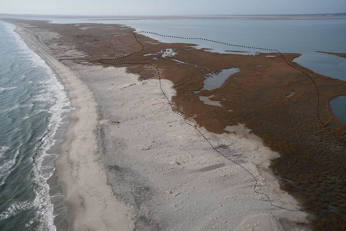
Cedar Island is a dynamic barrier island that is naturally migrating westward in response to erosion and sediment redistribution caused by storms, sea-level rise and other natural processes. Sea-level rise has accelerated migration and narrowing of the island, increasing the risk of future breaches, particularly at the site of a former inlet in the island that was open nearly continuously for 13 years. Without intervention, storm-driven overwash will deposit sediment into the backbarrier lagoon as the island migrates landward, filling space that could otherwise support a salt marsh platform upon which the island could perch. Low, unvegetated ponds and channels within the existing marsh at this site also funnel overwash, further eroding the back side of the island and increasing the likelihood of a future breach. Who is leading and designing the project?
While Accomack County is the formal project applicant, the proposed project is a public-private partnership composed primarily of William & Mary’s Batten School & VIMS scientists and Stantec engineers and staff, with additional collaborators from Randolph–Macon College and George Washington University. The scientists and Stantec engineers and staff are chiefly responsible for the design.How much will the project cost, and who is funding it?
The first phase of the project included conceptual design and mapping. This was initiated in 2018 and was supported by the National Fish & Wildlife Foundation Coastal Resilience Fund (NFWF-NCRF) grants program.The second phase of the project focused on finalizing engineering designs and permit applications. This was funded in 2022 by grants from NFWF-NCRF and the US Fish & Wildlife Service.
The third phase involves project implementation and construction and is currently under regulatory review. If approved, implementation will occur in stages to allow for modifications as needed, with the first stage supported by a $5 million NFWF-NCRF grant. In total, construction of the entire proposed project is estimated to cost about $18 million.
How is this project different from traditional shoreline stabilization?
Rather than employing traditional shoreline stabilization strategies such as shoreline hardening or beach nourishment on the ocean-facing side of the island, the project seeks to stabilize the site of a former breach by raising and widening the marsh on the lagoon side of the island. This essentially mimics the effects of overwash events and supplements natural processes supporting the westward migration of the island in a way that minimizes ecological harm and guards against a future breach without constructing hard structures or attempting to permanently fix the island in place.What exactly will be done on Cedar Island?
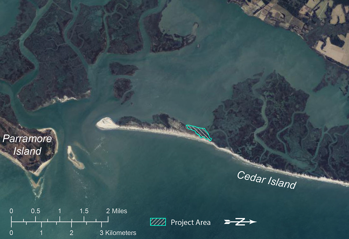
The project involves relocating a thin layer of sand from a nearby flood tidal delta inside of Wachapreague Inlet to the lagoon side of Cedar Island at its most vulnerable point. Native marsh vegetation will then be planted to help stabilize the sediment more quickly than natural colonization alone, and unvegetated corridors will allow migratory shorebirds to better utilize the area than existing conditions allow.Where will the sand come from?
Sand will be sourced from a flood tidal delta near the southern end of Cedar Island. This delta has grown at a rapid pace, roughly tripling in volume in the last five years. Although the project application allows for the removal of 1 to 3 feet of sand, the vast majority of the area is slated for removal of just 1 foot. This represents only a shallow skim of the delta’s sandy surface relative to the total sand thickness, which exceeds 12 feet. Beneath this top-most sandy layer, the shoal extends much deeper—reaching approximately 30 feet on the western side and 15 feet on the eastern side.Will this project affect shellfish aquaculture in the area?
The dredging area is dynamic and is being adjusted southward to encompass the current shoal extent and avoid overlapping a recently granted oyster ground lease. The sediment is sandy and will be moved using methods that minimize sediment resuspension. Placement in the project area will also use methods to minimize sediment resuspension and work will be conducted behind a turbidity curtain out of an abundance of caution, minimizing the likelihood of negative effects on shellfish aquaculture operations or wild shellfish resources.Could sediment dredging harm water quality?
No significant water-quality impacts are expected. The sediment is primarily sand, and the project will use a cutter-suction dredge with enclosed piping, which greatly limits sediment resuspension in the water column. Any sediment suspended into the water column during dredging or placement is expected to resettle quickly.Will removing sand change local currents or erosion patterns?
The volume of sand being relocated is small compared to the size of the flood tidal delta and the natural movement of sediment in the area. Based on the rate of accretion since the project was first mapped, scientists estimate that the flood tidal delta will regenerate in approximately one year.What are the environmental impacts at and around the project site?
Some localized impacts will occur, including burial of existing vegetation and benthic organisms at the placement site. These impacts are comparable to those that occur naturally during overwash events on barrier islands and are expected to be temporary, though they will affect an area larger than that typically created by a single storm-driven washover.Once completed, the project will strengthen the barrier island’s resilience to future storms and rising sea levels, helping to protect nearby communities. It will also support the growth and long-term health of highly productive back-barrier and wetland ecosystems that serve as nurseries for commercially valuable fish and shellfish and provide critical nesting and foraging habitat for migratory birds, including the saltmarsh sparrow, a species of greatest conservation concern in Virginia, and the piping plover, a state and federally threatened species.
How will wildlife and habitat be protected?
The project is designed to increase habitat connectivity for migratory shorebirds by leaving selected corridors unvegetated for foraging, movement and nesting. Wild oysters present in the project footprint will be relocated nearby prior to sediment placement. Some benthic organisms are likely to survive project construction and we expect polychaete worms and bivalves to begin recolonizing the area the first spring following sand placement. Nearly all of the benthic organisms found in the area have larvae that float in the water column, so animals living near the project will aid in recolonization. Based on previous natural events, the transition from an early to late successional benthic community is expected within approximately five years.How will invasive species be managed?
An invasive marsh grass, Phragmites australis, has been observed adjacent to the proposed project site. If phragmites spread into the project site prior to implementation, the project includes removal of phragmites existing within the project footprint prior to sediment placement and replanting with native marsh vegetation to reduce the likelihood of recolonization. After construction, long-term monitoring will track whether and how phragmites and other vegetation spread into the project area, with particular attention paid to bird corridors.What happens if the marsh plants do not survive?
If planted vegetation fails to establish, some sediment may be redistributed into the back-barrier lagoon, an outcome similar to what would occur during a natural overwash event. Even in this scenario, the project does not create additional risk beyond existing natural processes and will recolonize naturally over the subsequent years.Is this project experimental?
While the approach is innovative, it is grounded in decades of peer-reviewed research on Virginia’s barrier islands and beyond and builds on well-established understanding of coastal engineering, sediment dynamics, marsh–island interactions and sea-level rise.
What happens next?
The project is currently undergoing regulatory review. If approved, next steps will include updated mapping of existing conditions, final design refinements, site preparation, sediment placement and marsh planting. Project implementation will occur in stages, allowing for modifications as needed. Pre-, concurrent-, and post-construction monitoring will be conducted to assess project performance and environmental impacts over time.