Frequently Asked Questions
Wetlands Boards
What is a local Wetlands Board and who appoints the members?A Wetland Board is a regulatory body comprised of citizens of a locality that administers the Virginia Tidal Wetland Act provisions of state law. For information on the number, requirements, and make-up of a board, see Being on a Board |
What qualifications are required to be a Wetlands Board member?Each wetlands board member needs to be a resident of the locality in which they will serve. Typically, there are no requirements by a locality to serve on a wetlands board – however some demonstrated interest in the environment, shorelines, coastal erosion, or marine related issues is helpful and valuable. Prior training to serve on a wetlands board is not essential – although an interest in learning about your role and the issues you may confront as a board member is essential. VIMS offers regular training to wetlands board members and local staff on a wide variety of topics and holds an annual workshop which allows for board members, local staff, and others interested in shoreline issues to interact and share information. Learn more about training in Know Your Resources |
How are the Wetlands Board’s jurisdictional areas and determined?Wetland Boards are responsible for determination of jurisdictional tidal wetlands based upon the criteria in state law; lands contiguous to mean low water (MLW), within an elevation from MLW up to an elevation of 1.5 times the local tidal range for vegetated wetland or from MLW to mean high water for nonvegetated wetlands, and upon which are growing plants listed in state law. Typically, local wetland board staff make the determination of jurisdictional area. Assistance in making a determination may be provided by VIMS, VMRC (or SWCD on Agricultural lands). Note - The Corps makes determinations based on slightly different criteria and the tidal wetlands under their jurisdiction may or may not be of the same extent. See Who do I Ask? for help with the permitting process. |
How is it determined where MHW, MLW, and the landward extent of vegetated tidal wetlands are located?The precise determination of MLW and MHW location is made scientifically using a tidal epoch record of 19 years of water level observations. However, the location of MHW and MLW is typically estimated by site observations made during a mean tide condition on days that occur between spring tides (the greatest range of tides from lowest to highest when there is a full moon) and neap tide (when tidal range is at it minimum and there is a new moon). If a wetland board is not in agreement with the identified location mean high water and mean low water a tide gauge may be employed to collect water level data. The VMRC provides oversight on the use of tide gauge data to locate MLW and MHW elevation. For contact information for the VMRC by locality look here: Wetlands Boards. |
Why are public hearings required and how are they conducted?A public hearing is required by state law for wetlands permits. Details on the hearing and permit review process can be found under Conduct a Hearing. |
Are Wetlands Boards required to make site visits?Wetlands boards handle site visits in various ways. Board members are strongly encouraged to visit sites in advance of a hearing and with the applicant present. Some boards hold a monthly application site visit attended by multiple board members and organized and attended by local board staff. Board members also often visit sites on their own. In any case, it is best practice to always try to contact the applicant in advance of a planned visit as a courtesy, as well as have some documentation (business card or letterhead) from your locality proving that you are a wetlands board member. In cases where a visit occurs and the applicant is not present, it is best to leave a note that you have visited and include your contact information. More than three board members meeting for any reason - including site visits - requires the locality to issue a public notice of that meeting. Read more about Being on a Board. |
Are Wetlands Boards allowed to consider project impacts outside of the Board’s jurisdiction (in riparian buffers or subaqueous lands)?Permit Information (under Part 1 - General Information) details the required items for the JPA listed in state law and includes equipment use and access. Project access is either via overland or from the water, both of which may have impacts on riparian buffer and subaqueous lands. In addition, shoreline projects frequently incorporate bank grading which includes upland area landward of tidal wetlands in the riparian buffer area. Also see more information on Laws & Jurisdictions. |
How and when can a citizen file a protest about a project they don’t agree with?Any citizen can attend a public hearing and offer comment during the comment period of the hearing. Once a decision is made, a request to review that decision requires that twenty-five or more freeholders of property within the locality sign and submit a petition to the VMRC. All requests for review or appeal shall be made within ten days of the date of the board’s decision. The Commission shall hear and decide the review or appeal within forty-five days of receiving the request or notice of appeal. For more on the appeals process see: Conduct a Hearing. |
Where can I find more information for my county or city?
Virginia's coastal counties and cities each have a CCRMP Locality Portal; one stop for current and historic shoreline management information. Here you will find interactive mapping tools, shoreline and tidal marsh inventory reports, sea level rise and flooding information, GIS data for downloading, and other locality-specific VIMS shoreline publications. |
Shoreline Projects
Do I have an erosion problem?Erosion is a natural process occurring along most Chesapeake Bay shorelines. Bare soil areas without vegetation, numerous fallen trees, collapsing banks, and gradual shoreline retreat are all signs of erosion. Not all erosion is a problem that needs to be corrected. If the erosion rate is very slow and the risk is low if the erosion continues, then consider leaving the shoreline in a natural condition. If the erosion cannot be tolerated and needs to be reduced, then first consider if a Living Shoreline method may be effective. |
I have an erosion problem along my shoreline. Who should I contact?To evaluate the erosion issue along your shoreline and receive technical assistance on possible solutions, the following resources are available free of charge.
|
How do I get approval to modify my existing shoreline management approach to address sea level rise or changes in erosion?State law includes provision for maintenance of existing shoreline structures (which can include vegetation and coir logs) in place within the same footprint. In other words, as long as there are no new, additional impacts to tidal wetlands, beaches or dunes. If the proposed repair or modification will impact jurisdictional area, a new permit will be required. For instance, adding height to an offshore sill or breakwater will most likely result in a change in the side slopes and bigger footprint with new impacts. This would require a permit. |
What permits do I need to get approval to fix my shoreline?One application, the Joint Permit Application (JPA), is used to request approvals for proposed shoreline erosion control projects from all permitting agencies, hence the name Joint Permit. The JPA can be obtained from the Virginia Marine Resources Commission (VMRC), your local wetlands board office, or from the web at the Army Corps of Engineers and other locations. Once the JPA is completed, it is submitted to the VMRC which serves as the clearinghouse and distributes the joint application to the following agencies for review: VMRC, Army Corps of Engineers, DEQ and the local wetlands board. The applicant is responsible for ensuring approvals from all applicable agencies have been issued prior to starting a project. If you are proposing a living shoreline project that meets the requirements for a General Permit, a joint permit application is still required, but a wetlands board public hearing is not. The purpose of a general permit is to provide a streamlined permitting process as incentive to encourage property owners to utilize a living shoreline approach where appropriate. |
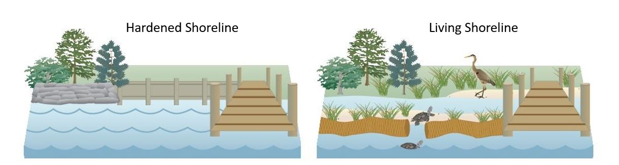
What is a living shoreline?Living Shorelines are nature-based approaches for protecting shorelines. They not only protect the shoreline from erosion but conserve, create or restore natural shoreline habitats and ecosystem services. |
Are there any examples of living shorelines that I can go see?Yes! Living shoreline demonstration sites are located throughout Tidewater. Some of these sites are self-guided and other require making arrangements for a visit. See story maps of resilient shorelines in Virginia on ADAPTVA. |
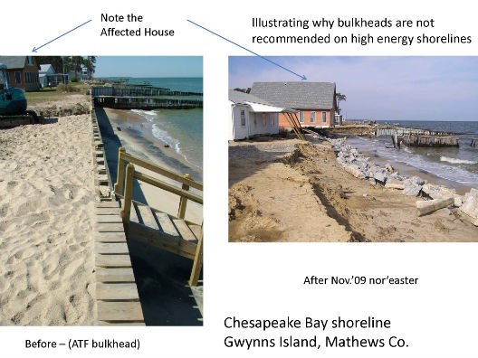
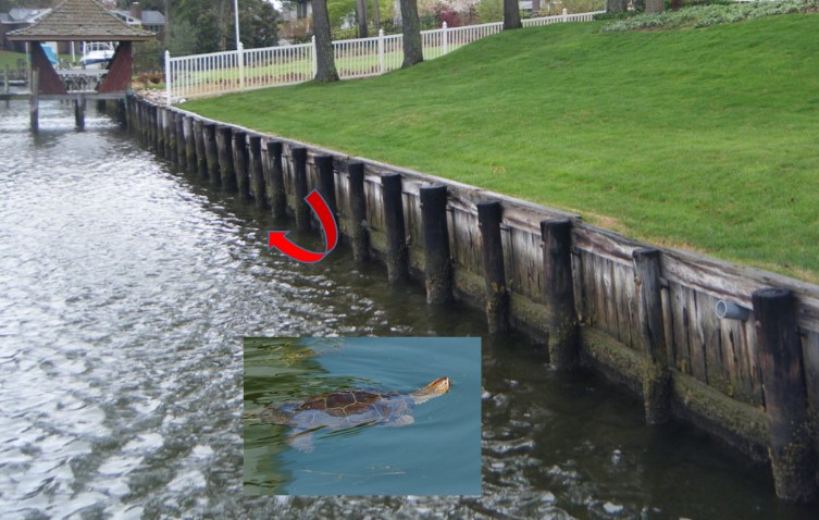
Why is a bulkhead not a good option for most shorelines?A bulkhead is an option for certain shorelines such as canals and marinas where navigation limits the use of other options. However, on shorelines where other options are feasible, bulkheads are not recommended for several reasons.
|
Where do I find a marine contractor to do my shoreline work?
|
How much does a living shoreline project cost?The construction costs for living shoreline projects and other stabilization methods vary widely depending on the shoreline length, level of protection needed, and the costs for materials and labor. Non-structural methods cost an average $50 - $100 per foot, such as beach nourishment and planted marshes. Projects with sand fill and/or stone structures typically cost $150 - $500 per foot. This does not include permitting costs. Upfront construction cost is only one factor to consider. The value of ecosystem services provided by living shorelines help offset these costs indirectly over time. |
Are there any programs available to help fund my shoreline project?Yes! Find out more information on these three funding programs here, Restoration & Resilience.
|
Who can I contact for more information?
For permit processing questions or advice see Who Do I Ask? For other assistance see CCRM's Staff Directory or [[wetlan-webmaster, Contact Us]] and we will direct your question to the appropriate person who will get back to you as soon as possible.