Taskinas Creek
 Taskinas Creek reserve encompasses 397 ha (980acres) within the boundaries of York River State Park. The Taskinas Creek watershed is representative of an inner coastal plain rural watershed within the southern Chesapeake Bay system. The watershed is dominated by forested and agricultural land uses with an increasing residential land use component.
The non-tidal portion of Taskinas Creek contains feeder streams that drain oak-hickory forests, maple-gum-ash swamps and freshwater marshes. Freshwater mixed wetlands are found in the upstream reaches of Taskinas Creek. Three-square (Scirpus americanus and S. olneyi) and big cordgrass (Spartina cynosauroides) characterize the middle marsh reaches. Salt marsh vegetation dominated by Spartina alterniflora is found in the lower reaches of the creek, near the outlet to the York River. Taskinas Creek is roughly 2 meters deep and 20 meters wide towards the lower end of the creek. Tides are semi-diurnal and range from 0.4-1.2 m, averaging 0.85 m. Sub-tidal substrate is dominated by fine sediments.
Mean water temperature from 1997 to 1998 was 5-7 °C during the winter and 26-28 °C in the summer. The minimum and maximum water temperature recorded between 1996-1998 was - 0.7 °C in January of 1996 and 35.1 °C in July 1998. Mean salinity in Taskinas Creek was on the order of 14-16 ppt in the summer and 3-5 ppt in the winter for 1997-1998. Minimum and maximum salinity recorded in 1996 - 1998 was 0.1 ppt in March 1996 and 20.3 ppt in November 1998. Mean dissolved oxygen values in 1996 and 1997 were lowest in the summer and greatest in the winter. Mean dissolved oxygen values below 50% saturation were only observed during parts of July 1996 and June 1997. Hypoxia was rarely observed and when present, lasted less than 2% of the time. Mean dissolved oxygen readings > 100% saturation (supersaturation) were frequently observed. Wildlife populations are known to influence microbiological water quality in Taskinas Creek.
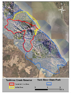
Location: The Taskinas Creek component (37° 24' N; 76° 42' W) is located within the boundaries of YRSP near the town of Croaker, in James City County, Virginia. The small subestuary of the York River is located on the southern side of the river, approximately 28 km (17 mi) upriver from VIMS and 38 km (24 mi) from the mouth of the York River.
Ownership and Management: YRSP contains 1034 ha (2554 ac; includes 44.5 ac Harrison tract acquired in 2003). All lands within the boundaries of YRSP are owned by the Commonwealth of Virginia. Lands within the Taskinas Creek Reserve component of YRSP, identified as the Taskinas Creek Management Unit in the YRSP Resource Management Plan (VaDCR 2000b), are co-managed by the Virginia Department of Conservation and Recreation (VaDCR) and VIMS in a manner consistent with the MOU between VIMS/W&M and the VaDCR dated August 19, 2008.
Physical Conditions: Taskinas Creek water quality is influenced to a large degree by watershed drainage at low tide and mainstem York River during high tide conditions. Tides are semi-diurnal and display an average range of 1.0 m (3.3 ft). Mean seasonal water temperature values range from 15.2-19.0 °C (59.4-66.2 °F) for spring, 26.8-28.2 °C (80.2-82.8 °F) for summer, 15.7-18.3 °C (60.3-64.9 °F) for fall, and 3.6-9.0 °C (38.5-48.2 °F) for winter. Located within the meso-polyhaline region of the York River estuary, mean seasonal salinity values range from 4.0-14.0 psu for spring, 7.0-18.2 psu for summer, 6.9-17.0 for fall, and 5.8-15.3 psu for winter. Summary water quality statistics were derived from SWMP 15-minute interval data for the years 1998-2004.
Representative Coastal Habitats: The Taskinas Creek component consists of a 285 ha (704 ac) core and 148 ha (366 ac) buffer region within the boundaries of YRSP. The upper, most inland boundary of the core area coincides with the 30.5 m (100 ft) contour and the seaward boundary of the core and buffer is defined by the 0.3 m (1 ft) water depth contour which delineates the seaward limit of the intertidal zone. The non-tidal portion of Taskinas Creek contains feeder streams that drain oak-hickory forests, maple-gum-ash swamps and freshwater marshes. Freshwater mixed wetlands are found in the upstream reaches of Taskinas Creek. Three-square (Scirpus americanus and S. olneyi) and big cordgrass (Spartina cynosuroides) characterize the middle marsh reaches. Salt marsh vegetation dominated by smooth cordgrass (Spartina alterniflora) is found in the lower reaches of the creek, near the outlet to the York River.
Rare Plant and Animal Species: A population of mountain camellia (Stewartia ovata) (G4/S2), first discovered in 1990, was rediscovered at the Reserve in 2006. Thirty two plants were located in six subpopulation areas (Meyers et al. 2008a). One bald eagle nesting location is known just outside the boundary of YRSP and the Taskinas Creek Reserve. Eagles use both the water and upland resources within the Reserve boundary for fishing and nesting and are therefore considered in this management plan.
Cultural and Historic Resources: Archaeological studies have been conducted within YRSP. Two sites of interest have been dated to between 1000 B.C. to 1500 A.D. (Egloff, 1988). Of significance is a previously undefined type of ceramic ware (Croaker Landing) and type of projectile point (Potts Side-Notched). Additional information and archaeological/historical sites and areas of archaeological resource potential within YRSP are provided in the YRSP Resource Management Plan (VaDCR 2000b).
Identified Management Issues: Identified resource management issues for the Taskinas Creek component of the Reserve and its immediate surrounding region include: (1) control of known problem invasive plant species which include the common reed (Phragmites australis), (2) assessment of sea level rise and shoreline erosion on critical habitats and geomorphic features, (3) source tracking of tidal creek fecal coliform contamination and development of remediation strategies, (4) assessment of increased development and public access pressures on natural resources, (5) enhanced survey of archaeological resources and development of an archaeological resource management plan, (6) determination of Reserve and YRSP carrying capacity to accommodate public use, research and education, (7) assessment of foot, bike and horse traffic on trail system, and (8) unauthorized public use of the Reserve which includes non-permitted collection of plants and animals, artifact collection, and unleashed dogs and cats.
Monitoring Programs:
Water Quality Monitoring - An Endeco YSI Environmental Monitoring System PC6000 or PC6600 is deployed in a permanent station near the mouth of the creek 2 meters from shore. Average water depth at the station is approximately 1.5 meters. Sub-tidal substrate at this site is dominated by fine sediments (42% fine sand, 30% clay and 28% silt). Water temperature, depth, pH, dissolved oxygen, salinity and turbidity have been recorded at the Taskinas Creek since September 1995. Since 2002, water column inorganic nutrients (ammonium, nitrate, nitrite, ortho-phosphate), total dissolved nitrogen and phosphorus, and chlorophyll are determined monthly at the water quality monitoring station. In addition, these parameters are determined once a month over a diel sampling period at a 2.5 hr sampling interval.
Biological Monitoring - The York River at the Taskinas Creek inlet was added as a sampling station for the CBNERR York River shallow water seine survey in 2001. Fish, blue crab and grass shrimp size and density data were collected monthly from February through July. Please contact Reserve staff for more information regarding this or any other CBNERR monitoring program.
Meteorological Monitoring - A Campbell Scientific UT-10 meteorological station records wind speed and direction, air temperature, relative humidity, rainfall, barometric pressure and photosynthetic active radiation (PAR). The weather station was established in April 1998 and is currently operational.