Sweet Hall Marsh
 Sweet Hall Marsh is the lower-most extensive tidal fresh water marsh located in the Pamunkey River, one of two major tributaries of the York River. The reserve is 353 ha (871 acres) in area and includes 331 ha (818 acres) of emergent fresh-water marsh, 14 ha (35 acres) of permanently flooded broad-leaved forested wetlands and approximately 4 ha (9 acres) of scrub-shrub. The marsh community is classified as freshwater mixed. Vegetation in the creekbank zone of Sweet Hall Marsh includes arrow arum, smooth cordgrass, big cordgrass, smartweeds, rice cutgrass, wild rice, water hemp, water dock, Walter's millet and marsh milkweed. Sedges (Carex spp.), reed grass, rushes (Scirpus spp.), cattail, marsh mallow and panic grass can be found in the levee zone of the marsh along with species found along the creekbank. The low marsh interior is dominated by arrow arum. The sensitive jointvetch (Aeschenomene virginica), a candidate for federal listing as an endangered species, is found in Sweet Hall Marsh. Mean tidal range at Sweet Hall Marsh is on the order of 0.9 m.
Location and Access:
Location: Sweet Hall Marsh (37° 34' N; 76° 50' W) is located in the tidal freshwater-oligohaline transitional zone of the Pamunkey River, one of two major tributaries of the York River, and has historically represented the lower-most extensive tidal fresh water marsh located in this riverine system. Sweet Hall Marsh is approximately 23 km (14 mi) from West Point, where the Pamunkey and Mattaponi converge to form the York River. The site is 65 km (40 mi) upriver from VIMS and 75 km (47 mi) from the mouth of the York River.
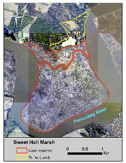
Ownership and Management: Sweet Hall Marsh is privately owned by the Tacoma Hunting and Fishing Club. Parcel size is 384 ha (949 ac) for tract 18 and 59 ha (145 ac) for the buffer tract 17. The Tick Hill tract, identified as parcel 12 (76 ha; 189 ac) in the 1991 Reserve Management Plan, was sold in 2000 by the Chesapeake Corporation to a private citizen. An updated MOU between VIMS/W&M and the new owner does not currently exist and therefore the Tick Hill tract is no longer included in the Reserve. VIMS serves as the on-site manager of the Sweet Hall Marsh component of the Reserve and assures consistency with the Sweet Hall National Estuarine Research Reserve in Virginia Management Agreement dated May 1, 2008.
Physical Conditions: Tides at Sweet Hall Marsh are semi-diurnal and display an average range of 1.0 m (3.3 ft). Mean seasonal water temperature values range from 14.7-16.7 °C (58.5-62.1 °F) for spring, 26.7-27.9 °C (80.1-82.2 °F) for summer, 18.6-19.1 °C (65.5-66.4 °F) for fall, and 4.7-6.3 °C (40.5-43.3 °F) for winter. Located within the oligohaline, lower freshwater reaches of the Pamunkey River, mean seasonal salinity values range from 0.1-3.4 psu for spring, 0.1-8.4 psu for summer, 0.3-8.4 psu for fall, and 0.1-3.2 psu for winter. Summary water quality statistics were derived from SWMP 15-minute interval data for the years 2002-2004.
Representative Coastal Habitats: The Sweet Hall Marsh component consists of a 384 ha (949 ac) core region that encompasses emergent, fresh and low salinity marsh, seasonally flooded forested wetlands and scrub-shrub wetlands. A 59 ha (145 ac) buffer consists primarily of uplands forests and open agricultural fields. The emergent marsh community is classified as freshwater mixed and includes arrow arum (Peltandra virginica), big cordgrass (Spartina cynosuroides), smartweeds (Polygonum spp.) species, rice cutgrass (Leersia oryzoides), wild rice (Zizania aquatica), sedges (Carex spp.) and rushes (Scirpus spp.), cattail (Typha spp.) and panic grass (Panicum virgatum). The dominant canopy species in the flooded forested wetlands include green ash (Fraxinus pennsylvanica), black gum (Nyssa sylvatica), red maple (Acer rubrum) and ironwood (Carpinus caroliniana). Scrub-shrub species include wax myrtle (Myrica cerifera L.), mountain laurel (Kalmia latifolia) and arrow wood viburnum (Viburnum dentatum). The uplands in the buffer zone consist of agricultural fields and mixed hardwoods and pine.
Rare Plant and Animal Species: The sensitive joint vetch (Aeschenomene virginica), a candidate for federal listing as an endangered species, has historically been found at Sweet Hall Marsh but has not been found in recent surveys. Fauna surveys conducted to date have found the butterfly species (Problema bulenta), a "Rare Skipper" species that has both a global and state rare ranking (Myers et al. 2008b). Several bald eagles nesting locations are located near, but not within the boundaries of Sweet Hall Marsh. Eagles use both the water and upland resources within the Reserve boundary for fishing and resting and should be considered in management plans.
Cultural and Historic Resources: Sweet Hall Marsh has not been surveyed for archaeological resources. Due to its long history of human use, it is expected that Sweet Hall Marsh and adjacent uplands would yield significant prehistoric and historic resources.
Identified Management Issues: Identified resource management issues at Sweet Hall Marsh and immediate surrounding region include: (1) assessment and control of problem invasive plant species which may include the non-native common reed (Phragmites australis), (2) assessment of relative sea level rise impacts (includes subsidence due to ground water withdrawal and other factors) on plant communities, (3) assessment of long-term reductions in stream flow on salinity patterns and the impacts on plant communities and fish spawning grounds, (4) source identification of mercury inputs and impacts upon the ecosystem, (5) assessment of introduced Blue catfish populations and impact on local fish populations (6) assessment of increased development and public access pressures on natural resources, and (7) survey of archaeological resources and development of archaeological resource management plan.
Monitoring Programs:
Water Quality Monitoring - An Endeco YSI Environmental Monitoring System PC6000 or PC6600 is deployed in a permanent station built 3 meters from the bank in the Pamunkey River. The station is adjacent to Sweet Hall Marsh on the downriver side. Water temperature, water depth, pH, dissolved oxygen, salinity and turbidity have been recorded since January 1999. Beginning in 2002, water column inorganic nutrients (ammonium, nitrate, nitrite, ortho-phosphate), total dissolved nitrogen and phosphorus, and chlorophyll are measured monthly at the water quality monitoring station.
Biological Monitoring - Many research projects investigating the freshwater marsh plant community and nekton utilization of the marsh, intertidal zone and subtidal waters around Sweet Hall marsh have been conducted. Please contact Reserve staff for more information regarding this or any other CBNERR monitoring program.
Meteorological Monitoring - A Campbell Scientific UT-10 meteorological station records wind speed and direction, air temperature, relative humidity, rainfall, barometric pressure and photosynthetic active radiation (PAR). The weather station is located in an agricultural field immediately adjacent to the marsh. The weather station was established in March 1998 and is currently operational.