The Goodwin Islands
 The Goodwin Islands are a 315 ha (777 acre) archipelago of salt-marsh islands surrounded by inter-tidal flats, extensive submerged aquatic vegetation (SAV) beds (121 ha; 300 acres), a single constructed oyster reef and shallow open estuarine waters. Salt marsh vegetation is dominated by salt marsh cordgrass (Spartina alterniflora) and salt meadow hay (Spartina patens). Forested wetland ridges are dominated by estuarine scrub/shrub vegetation. Mixed oak and pine communities are found on upland ridges located on the largest island. Water circulation patterns around the island are influenced by York River discharge and wind patterns of the Chesapeake Bay. Tides at the Goodwin Islands are semi-diurnal and display an average range of 0.7 m (range: 0.4 - 1.1 m).
Water quality ranges listed here were observed from data recorded between October 1997 and December 1998. Mean water temperature at the Goodwin Islands sampling station ranged from 7 °C in winter to 27 °C in summer. Minimum and maximum water temperatures recorded were 2.3 °C (January) and 31.6 °C (July). Mean monthly salinity ranged from 9.9 ppt (January) to 27.5 ppt (November). Mean salinity was greatest (23-25 ppt) during the summer and fall and lowest (13-15 ppt) during the winter and spring. Mean dissolved oxygen readings were near saturation during the examined time period except between July-August. Dissolved oxygen readings ranged from 23.6% (October) to 195.7% saturation (May); hypoxia is rarely observed.
Location and Access:
The Goodwin Islands (37° 13' N; 76° 23' W) component of the CBNERR is located on the southern side of the mouth of the York River. The islands are at the northeastern tip of York County approximately 22 km down the York River from VIMS. The Goodwin Islands are accessible only by boat. The nearest mainland is 0.2 km across the Sand Box Thoroughfare. Permission is required for specific activities on the island. Please call the Research Reserve office for further information.
Goodwin Islands
Ownership and Management: Goodwin Islands are owned by the College of William and Mary. VIMS serves as the on-site manager of the islands and assures consistency with the MOU between VIMS/College of William and Mary and NOAA dated February 6, 1991.
Physical Conditions: Water circulation patterns around the islands are influenced by York River discharge and wind patterns of the Chesapeake Bay. Tides at the Goodwin Islands are semi-diurnal and display an average range of 0.7 m (2.3 ft). Mean seasonal water temperature values range from 13.7-15.6 °C (56.7-60.1 °F) for spring (March-May), 25.7-27.2 °C (78.3-81.0 °F) for summer (June-August), 18.0-19.2 °C (64.4-66.6 °F) for fall (September-November), and 4.7-8.2 °C (40.5-46.8 °F) for winter (January-February, and December). Located within the polyhaline region of the York River estuary, mean seasonal salinity values range from 13.9-23.0 psu for spring, 17.2-23.0 psu for summer, 16.5-24.0 for fall, and 15.9-23.3 psu for winter. Summary water quality statistics were derived from SWMP 15-minute interval data for the years 1998-2004.
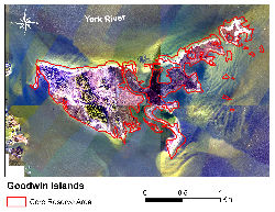
Representative Coastal Habitats: Consisting of an archipelago of salt-marsh islands, the Goodwin Islands component core area is approximately 148 ha (366 ac) in area. Primary ecological community groups occurring at Goodwin Islands include tidal meso-polyhaline marshes, maritime dune grasslands, salt scrub, and maritime upland forest (Erdle and Heffernan 2005a). Salt marsh vegetation is dominated by smooth cordgrass (Spartina alterniflora) and saltgrass (Distichlis spicata). Other marsh associates include salt meadow hay (Spartina patens), glasswort (Salicornia virginica), sea-lavender (Limonium carolinianum), and stands of black needlerush (Juncus roemerianus). Characteristic species of the narrow stands of maritime dune grasslands include saltmeadow hay (Spartina patens), beach panic grass (Panicum amarum), seaside goldenrod (Solidago sempervirens) seaside spurge (Chamaesyce polygonifolia) and searocket (Cakile edentula). Salt shrubland community, consisting primarily of groundsel tree (Baccharis halimifolia) and saltbush (Iva frutescens), is irregularly scattered along low dunes and the island perimeter. The higher, interior western portions of the Goodwin Islands support a large stand of loblolly pine (Pinus taeda) with some mixed oak. The understory is dominated by southern wax myrtle (Myrica cerifera) and to a lesser degree red bay (Persea palustris). The northwestern corner of the island contains a fringe forest of sugarberry (Celtis laevigata), slippery elm (Ulmus rubra) and cottonwood (Populus deltoides); understory consists of Chinese privet (Ligustrum obtusifolium) and other shrub species. The surrounding aquatic zone includes extensive SAV beds of eelgrass (Zostera marina) and widgeon grass (Ruppia maritima) approximately 183 ha (453 ac) in area (Orth et al. 2005), large expanses of unvegetated bottoms, and shallow open estuarine waters.
Rare Plant and Animal Species: Flora and fauna surveys conducted to date do not indicate the presence of rare plant and animal species. Breeding bald eagles have been documented in recent years, although Tropical Cyclone Isabel damaged nesting habitat in the fall of 2003 (Watts, pers. comm., 2004).
Cultural and Historic Resources: An archaeological survey has not been conducted at Goodwin Islands. Based on observations and personal communications, Goodwin Islands contains prehistoric and historic resources.
Identified Management Issues: Identified resource management issues on Goodwin Islands and the immediate surrounding region include: (1) control of known problem invasive plant species which include common reed (Phragmites australis), japanese honeysuckle (Lonicera japonica), japanese stilt grass (Microstegium vimineum), and border privet (Ligustrum obtusifolium), (2) control of native animal problem species which include raccoon (Procyon lotor), fox species and white-tailed deer (Odocoileus virginicus), (3) assessment, protection and restoration of critical spawning, nesting and nursery habitat with specific emphasis on colonial nesting birds such as the great blue heron (Ardea herodias), horseshoe crab (Limulus polyphemus) spawning grounds, breeding and nesting areas for shorebirds including American oystercatchers (Haematopus palliates), and diamondback terrapins (Malaclemys terrapin), (4) assessment of sea level rise and shoreline erosion on critical habitats and geomorphic features, (5) restoration of submerged aquatic vegetation beds to past aerial coverage, (6) continued implementation of hunting management plan, (7) assessment of direct and indirect impacts of fishing activity on natural resources, (8) development of petroleum/toxic material spill contingency and response plans, (9) development of a fire contingency plan, (10) assessment of increased development and public access pressures on natural, cultural and historic resources, (11) survey of archaeological resources and development of a archaeological resource management plan, and (12) unauthorized public use of the Reserve which includes non-permitted collection of plants and animals, artifact collection, unleashed dogs and cats, and camping.
Monitoring Programs:
Water Quality Monitoring - An Endeco YSI Environmental Monitoring System PC6600 or PC6000 is deployed in a permanent station on the southeastern side of the islands. The sampling station is located in a shallow embayment approximately 400 meters from shore. Average water depth at the station is on the order of 1 m. Beds of submerged aquatic vegetation dominated by eelgrass (Zostera marina) and Widgeon grass (Ruppia maritima) are interspersed with unvegetated subtidal sand flats surround the sampling station.
Water temperature, depth, pH, dissolved oxygen, salinity and turbidity have been recorded semi-continuously (15 minute interval) at the Goodwin Islands since October 1997. Water column fluorescence, an indirect measurement of chlorophyll-a, began in 2001. Since 2002, water column inorganic nutrients (ammonium, nitrate, nitrite, ortho-phosphate), total dissolved nitrogen and phosphorus, and chlorophyll are determined monthly at the water quality monitoring station.
Biological Monitoring - The Goodwin Islands are a sampling site for the CBNERR York River shallow water seine survey. Fish, blue crab and grass shrimp size and density data have been collected since 1997 from this site. The Goodwin Islands are sampled monthly from February - July. Information on research projects investigating the oyster population on a created subtidal oyster reef near the island, the salt marsh plant community and nekton communities in the marsh, submerged aquatic vegetation and the waters around Goodwin Island are also available. Contact Reserve staff for more information regarding CBNERR monitoring programs.