Catlett Islands
 Catlett Islands encompass 280 ha (690 acres) and displays a ridge-and-swale geomorphology. The islands consist of multiple parallel ridges of forested wetland hammocks, forested upland hammocks, emergent wetlands and tidal creeks surrounded by shallow subtidal areas that once supported beds of submerged aquatic vegetation.
In cross-section, the ridges are characterized by a marsh/shrub wetland ecotone, a shrub wetland/forested wetland ecotone, a ridge terrace, and an interior forested high ground. Plants found in the marsh/shrub wetland ecotone include salt marsh cordgrass (Spartina alterniflora), salt meadow hay (Spartina patens). Marsh elder and groudsel tree bushes thrive towards higher ground of the saltmarsh. The shrub wetland/forested wetland is characterized by a sparsely forested overstory dominated by young and/or stressed loblolly pine, red cedar and the occasional American holly and black cherry. The shrub layer in this ecotone contains wax myrtle, bayberry and saplings of loblolly pine, cedar, holly and black cherry plus a variety of vines.
The overstory of the ridge terrace is usually dominated by larger, densely distributed loblolly pine. Red cedar, holly, black cherry, red maple and persimmon grow in the subcanopy. The understory consists primarily of American holly and the shrub layer is dominated by wax myrtle, poison ivy, trumpet vine, bull briar, greenbriar and Japanese honeysuckle. Interior high ground of the forested wetlands contains more hardwood species than the ridge terrace although loblolly pine is always present. Several species of oak and tulip poplar, sourwood, black gum, sassafras, sweetgum, dogwood, red maple, black cherry, black locust, persimmon and holly are found here.
Location and Access:
The Catlett Islands (37° 18' N; 76° 33' W) are located approximately 35 km from the mouth of the York River and 7 km from VIMS on the North side of the York River in Gloucester County, Virginia. Timberneck Creek flows into the York River on the eastern side of the Catlett Islands and Cedarbush Creek enters the river on the western side. Poplar Creek bisects the two large areas of the Catlett Islands. The site is accessible primarily by boat. Permission for all activities on the island is mandatory. Please contact Reserve staff for information.
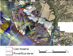
Catlett Islands
Ownership and Management: The Reserve core encompasses the entire Catlett Island ecological unit except for a small portion (Owner: D. and M. Ablowich; Size: 32 ha or 79 ac; Parcel ID: 88) located on the most northwest portion of the islands. The majority of land comprising the Catlett Islands component is owned by Timberneck LLC (Parcels 64, 87, 89, 90 and 91). Parcel size is 47 ha (115 ac) for tract 64, 63 ha (155 ac) for tract 87/89, and 45 ha each (112 ac) for tracts 90 and 91. VIMS/W&M holds deed to a small portion (20 ha; 48 ac) of the most southeast portion (Parcel 65) of the island complex. VIMS serves as the on-site manager of the Catlett Islands and assures consistency with the Catlett Island National Estuarine Research Reserve in Virginia Conservation Easements dated September 5, 1990 and November 14, 1990 and amended April 16, 2008.
Physical Conditions: Tides at the Catlett Islands are semi-diurnal and display an average range of 0.8 m (2.6 ft). Mean seasonal water temperature values range from 15.2-18.7 °C (59.4-65.7 °F) for spring, 25.2-28.5 °C (77.4-83.3 °F) for summer, 14.9-20.9 °C (58.8-69.6 °F) for fall, and 4.5-12.1 °C (40.1-53.8 °F) for winter. Mean seasonal salinity values range from 10.7-22.6 psu for spring, 15.1-23.1 psu for summer, 13.2-25.2 psu for fall, and 10.3-23.1 psu for winter. Summary water quality statistics were derived from weekly interval data from the Alliance for the Chesapeake Bay for the years 1995-2004.
Representative Coastal Habitats: The Catlett Islands component, approximately 220 ha (542 ac) of core area, consists of multiple parallel ridges of forested hammocks and emergent wetlands. Primary ecological community groups occurring at Catlett Islands include tidal meso and polyhaline marshes, forested wetlands and maritime upland forests (Erdle and Heffernan 2005b). Smooth cordgrass (Spartina alterniflora) prevails over much of the marsh area along with saltgrass (Distichlis spicata), saltmeadow hay (Spartina patens), black needlerush (Juncus roemerianus) and various halophytic forbs. Estuarine scrub/shrub vegetation including saltbush or high-watershrub (Iva frutescens), groundsel tree (Baccharis halimifolia), southern bayberry (Myrica cerifera) and northern bayberry (Myrica pennsylvanica), occurs in transitional areas from salt marsh to forested wetlands and hammock regions. Maritime upland forests, dominated by oak species (Quercus phellos, Q. falcata, Q. pagoda), loblolly pine (Pinus taeda) and to a lesser degree black cherry (Prunus serotina), red maple (Acer rubrum), black gum (Nyssa sylvatica) and other tree species dominate the higher terrain.
Rare Plant and Animal Species: Flora surveys conducted to date do not indicate the presence of rare plant species. Bald eagles have been documented on Catlett Island in years past and currently continue to utilize the Island. While there has been no successful breeding activity in recent years (2004-2005), a nest was rebuilt in 2005 and breeding activity is currently being evaluated (B. Watts, pers. comm.).
Cultural and Historic Resources: A cultural resource overview has been conducted for the Timberneck Farm and adjacent Catlett Islands (Blanton et al. 1993). The overview documented relatively few Archaic (10,000-2,500 yrs B.P.) sites, and on the order of ten each of Middle Woodland (2,500-1,000 yrs B.P.) and Late Woodland (1,000-400 yrs. B.P.) sites. With respect to historic sites, numerous site occupations from the seventeenth through twentieth centuries have been identified.
Identified Management Issues: Identified resource management issues on Catlett Islands and immediate surrounding region include: (1) control of known problem invasive plant species which include common reed (Phragmites australis), japanese honeysuckle (Lonicera japonica), and blunt-leaved privet (Ligustrum obtusifolium), (2) impact assessment and potential control of the southern pine bark beetle, (3) control of native animal problem species which include raccoon (Procyon lotor), fox species and white-tailed deer (Odocoileus virginicus), (4) assessment, protection and restoration of critical colonial bird nesting habitat with specific emphasis on the great blue heron (Ardea herodias), (5) assessment, protection and restoration of critical breeding and nesting areas for shorebirds including American oystercatchers (Haematopus palliates), (6) assessment of sea level rise and shoreline erosion on critical habitats and geomorphic features, (7) development and implementation of a hunting management plan, (8) development of a petroleum/toxic material spill contingency and response plans, (9) development of a fire contingency plan, (10) assessment of increased development and public access pressures on natural resources, (11) source tracking of tidal creek fecal coliform contamination and development of remediation strategies, (12) determination of water quality status for surrounding waters and assess the potential for SAV and oyster restoration, (13) enhanced survey of archaeological resources and development of an archaeological resource management plan, and (14) unauthorized public use of the Reserve which includes non-permitted collection of plants and animals, artifact collection, hunting and camping.
Monitoring Programs:
Water Quality Monitoring - There are no water quality or weather stations at the Catlett Islands component of the CBNERR. Weekly volunteer citizen water quality monitoring has been ongoing since the incorporation of the site in 1990. Surface water temperatures range from 5.4 °C to 27.4 °C. Salinity is indicative of mesohaline conditions, ranging from 14-18 ppt in the fall to 8.2-12 ppt in the spring. Dissolved oxygen concentration ranges from 4.2 to 14.0 mg/L. Beginning in 2002, water column inorganic nutrients (ammonium, nitrate, nitrite, ortho-phosphate), total dissolved nitrogen and phosphorus, and chlorophyll are measured monthly adjacent to Catlett Islands.
Biological Monitoring - Catlett Island is a sampling site for the CBNERR York River shallow water seine survey. Fish, blue crab and grass shrimp size and density data have been collected since February 2001 from this site. Nekton sampling occurs monthly from February through July. Contact Reserve staff for more information regarding this or any other CBNERR monitoring program.