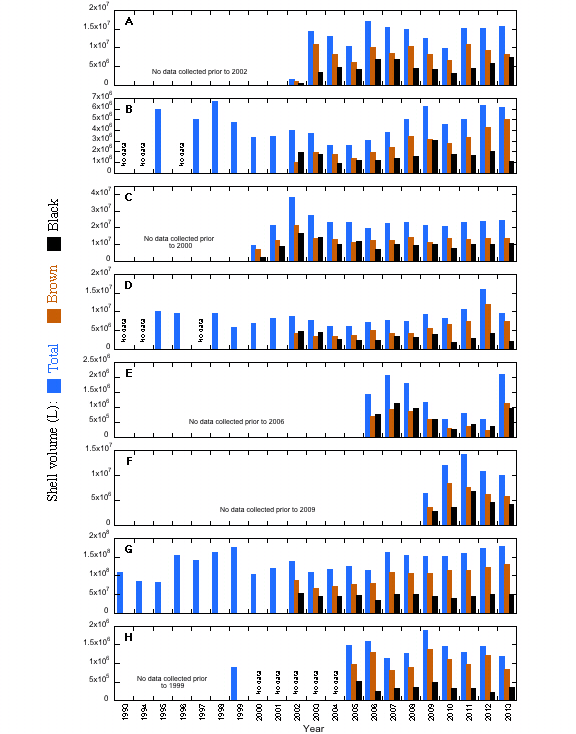
The VA survey has collected quantitative shell data for both brown (oxic exposed) and black (anoxic buried) shell since 2002 (2000 on some reefs), in some cases back to 1993 for a whole shell measurement. The current survey generates data on shell as density (shell volume per unit area), but there is also a need to consider areal extent of cover. Side scan sonar has been promoted as a method to resolve this question. Side scan sonar can define where oysters are absent, but ground verification is required where hard bottom is identified to eliminate false positive interpretation. Side scan has utility as a tool to focus survey activity, however, it cannot as yet be used as a quantitative substitute.
The VA shell resource is summarized as total, brown and black shell, by region/river since the initial dates of data collection. The time series is longest for the James River and is generally descriptive of the status of the whole oyster stock in three time periods: prior to the late 1990s epizootic, during the epizootic and the post epizootic recovery. The first and third periods have comparable shell volumes. The Great Wicomico and Piankatank data also cover the approximate period of that for the James and have comparable patterns of signal magnitude. Both include periods of shell planting in the post epizootic recovery period. The Rappahannock data set begins with a very large-scale shell planting effort as part of the Virginia Oyster Heritage Program in the late 1990s and early 2000s, followed by a modest decline and stability for the past decade. In all instances, the observed stability of the data in the absence of major epizootic impacts suggests we have arrived at a default BRP for “no net shell loss” under current practice. Future management actions must consider shell planting to offset losses incurred by harvest scenarios. The critical advice here is the continued availability of shell in sufficient volume and at a reasoned cost to maintain this balanced approach.
The Pocomoke/Tangier and the Elizabeth/Lafayette data sets show modest variation but in general suggest stability over time. By contrast, the Mobjack Bay and York River data sets illustrate temporal variability but are generally too short to draw conclusions as to long-term stability under present management protocols. These are both areas of recent restorative actions and caution must be strongly advised not to compromise gains that have been made. Both regions are managed on a rotational basis, an approach that has been successful in rebuilding the Rappahannock resource to the extent that it now supports a healthy fishery. A conservative approach to exploitation is advised for the near future.
 5.2 Link to Live Shell vs Dead Shell