VIMS receives USDA funding to map estuarine landscapes
New research could help Virginia go greener with “blue carbon”
New funding from the U.S. Department of Agriculture will enable researchers Julie Herman and Molly Mitchell of the Virginia Institute of Marine Science to better track the amount of organic matter stored in coastal ecosystems. This “blue carbon” can help reduce the impacts of climate change by removing excess carbon dioxide from the atmosphere.
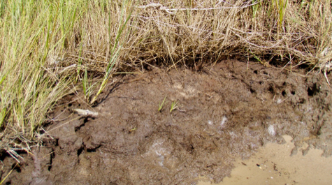
Seagrass meadows, mangrove forests, and salt marshes can store significant amounts of blue carbon because of their highly productive plants and typically stable sediments. However, marshes and other blue carbon reservoirs are declining in many areas. This decline can be largely attributed to human disturbance and erosion, which causes the carbon they store to be released.
The grant to Herman and Mitchell—provided through USDA’s Natural Resources Conservation Service (NRCS)—will provide the funding needed to develop a model for mapping and quantifying blue carbon stocks in coastal Virginia and North Carolina. The model will help citizens and managers make more informed decisions concerning conservation and preservation of coastal lands.
“Blue-carbon stocks in tidal marshes contain organic matter and mineral sediments transported from surrounding areas,” says Herman. “We hypothesize that the blue-carbon stock of a given tidal marsh can be predicted by soil survey and land cover data.”
Herman and Mitchell will work with NRCS Senior Regional Soil Scientist Greg Taylor to build on the agency’s existing soil surveys, which provide invaluable data on soil types but may be missing or have incomplete information for estimating blue-carbon stocks. 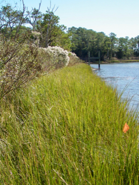 For instance, tidal fringe marshes are often overlooked because they are long narrow features and difficult to map remotely.
“NRCS soil scientists covered a lot of ground to map Virginia’s 26,090,600 acres of land, but we still have areas to improve on due, in part, to scale issues associated with wetlands,” says J. David Harper, State Soil Scientist. “This project will not only improve carbon-stock records but also enhance coastal-zone soil maps and soils data.”
“Understanding the magnitude of our marsh blue-carbon stocks can help us evaluate the importance of our wetlands and prioritize conservation efforts,” says Mitchell. “This grant is an exciting opportunity to partner with NRCS scientists and augment existing surveys with new data to answer emerging questions.”
GIS Modeling & Sediment Coring
The team’s model will be based on a digital “Geographic Information System.” The GIS will allow the researchers to map, analyze, and display spatial data at multiple scales; incorporate new remotely sensed and field data into soil surveys; and to augment and update those surveys with state-specific tidal marsh layers and land-cover data.
The researchers will also collect soil cores in tidal marshes, then process these to calculate carbon stocks for the individual marshes, and to establish statistical relationships for estimating carbon across marsh types and locations.
Herman and Mitchell, of the Center for Coastal Resources Management at VIMS, will begin collaborating with NRCS scientists on the two-year project in September 2019. Their deliverables include designing a web tool specific to blue-carbon stocks that will be hosted on the CCRM website, and delivering data to NRCS in a format compatible with NRCS soil surveys.
NRCS has supported this collaborative research for 12 years, accepting new proposals annually. This year, the agency received 32 applications and provided $1.9 million for 15 projects in 14 states. Awards are based on nationally and regionally identified needs on the land and in cities. The information gained from the collaborative research will advance the agency’s ability to provide science-based soil and ecosystem information to help address important natural resources issues facing our nation.
“Methodologies developed in this project should also be transportable to tidal marshes in other states in the Major Land Resource Area,” says Herman, “including New Jersey, Delaware, Maryland, South Carolina, and Georgia with some additional field work to verify the carbon relationships.” Usually several thousand acres, Major Land Resource Areas are characterized by a particular pattern of soils, climate, water resources, land uses, and type of farming.