Wetland Condition Assessment Tool (WetCAT)
The Virginia Institute of Marine Science, in collaboration with the Virginia Department of Environmental Quality (DEQ), developed the service capacity impairment model that is scalable from the individual wetland to the entire state.
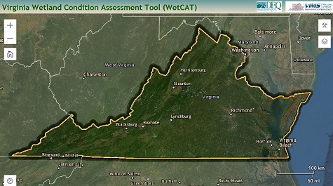
The Wetland Condition Assessment Tool (WetCAT) is a spatially-specific, interactive, online tool that provides a water quality and habitat condition assessment for each individually mapped nontidal wetland in Virginia (approximately 196,000 polygons and over 1.2 million acres). WetCAT also includes some tidal marsh and shoreline condition information. It provides VA DEQ staff and others a scientifically-based GIS process for evaluating projects that could impact wetlands. The goal of WetCAT is to support decision-making, allow reporting of wetland condition, and provide information for policy development.
Why are Wetlands Important? Wetlands provide a number of societal benefits and ecological functions and services. WetCAT focuses on two of those, the ability to enhance or protect water quality and the provision of habitat for a number of species. Stressors within the landscape can impact the ability of wetlands to provide those functions. The more stressed a wetland is the more likely it will have a reduced ability to protect water quality or provide habitat services. This is important to communities and important to natural resource managers as they decide whether or not to permit certain activities on the landscape that could further stress wetlands systems.
- WetCAT received a 2019 Governor’s Technology Award for "IT as Efficiency Driver – Government to Citizen", recognizing online tools that use IT to improve citizen access to and service from governmental entities.
- The US Environmental Protection Agency recognized VIMS wetland activities as one of the Nation’s 25 Exemplars of effective wetlands research and management.
- WetCAT was recognized by the Environmental Council of States (ECOS) as an outstanding state initiative that can serve as a model for other states.
- Link to WetCAT (Need help? Watch the included tutorial)
- Read more on Wetland and Stream Rapid Assessment