

The Bay of Whales
Our trip was far less dramatic and of much shorter duration. We arrived in the Bay early in the morning, and began our observations by completing a zooplankton tow. This was followed by a CTD (conductivity-temperature-depth) cast to collect water for analysis. We then went as far as we could into the Bay. Our intent—to be the ship that has gone as far south as it is possible to do by sea. Last year a New Zealand tourist vessel reported setting that record, and we were determined to establish ourselves farther south. In the end we were successful, and now have the deepest oceanic penetration of any ship.
Two of the CORSACS Principle Investigators (Rob Dunbar of Stanford and Walker Smith of VIMS) visited the Bay of Whales in 1983 on the USCGC Glacier. We did not have the exact recorded position from that year, but will compare it to our recent visit. It will undoubtedly be different, because the ice shelf continually moves northward, driven by the gravitational flow of ice down from the Antarctic Plateau. Large icebergs calve off when the ice shelf thins due to melting at its base and the shelf becomes unstable (seawater is warmer than the ice, even though seawater is at -1.86°C! By melting the ice at the ice-shelf's base, it becomes super-cooled and is less than -2°C, a condition made possible by the depth of the melting, which is ca. 250 meters. Otherwise the water would freeze immediately. If you bring the super-cooled water to the surface, that is exactly what happens!). Therefore, the position of the Bay shifts with time.
The name of the Bay clearly indicates that the early explorers found large cetacean populations in the vicinity. We, unfortunately, saw only one whale, a Minke; we did, however, see many pelagic birds (Antarctic and snow petrels), along with some penguins and a good number of crabeater seals. Many of these higher trophic levels feed on krill species, but our zooplankton collection in the morning was one of the smallest we have seen. It is likely that the Bay serves as a protected location and nesting site, and that feeding occurs farther to the east nearer to shallow regions of high production.
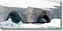
The scenery was indeed dramatic, with steep drop-offs from the ice shelf, numerous icebergs, and dramatic tunnels and bridges in the ice. Although we were impressed by the ice and the location, we soon had to return to our science and began a transit to 75°S, where our last CORSACS transect will begin. We also have to refuel from the fuel tanker when it arrives in McMurdo Sound, but at present we do not know when this will be. Until we need to break off science for this operation, we will continue to sample along the transect.