Loftis partners in market challenge
Prize honors pair for ideas to enhance coastal-flooding app
A team led by Dr. Derek Loftis of William & Mary’s Virginia Institute of Marine Science shared second place in a market-based challenge to conceptualize new ways of enhancing a mobile app that was developed to help citizens, scientists, and emergency managers better monitor and respond to coastal flooding.
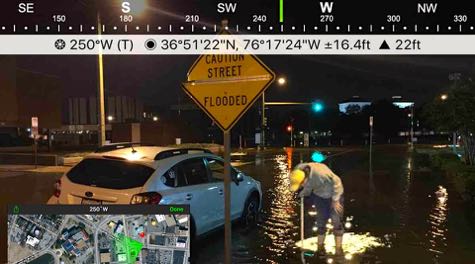
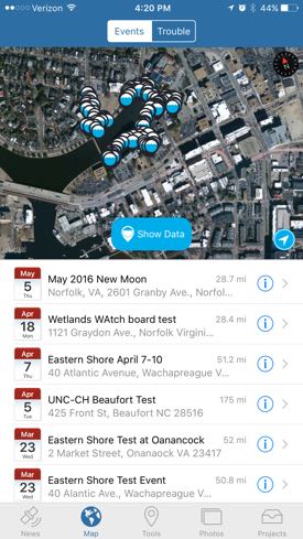
The Sea Level Rise App©, developed by the Norfolk-based non-profit Wetlands Watch, allows users to map flooded areas in their neighborhoods using the GPS unit and camera on their iPhone or Android. It first saw use in Hampton Roads—second only to New Orleans as the U.S. area most threatened by sea-level rise—but can be used on any coastline around the world.
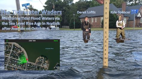
Loftis, VIMS professor Harry Wang, and other colleagues have been using data from the app to check and improve the accuracy of flood forecasts generated by their high-resolution computer model. They’ve done so both during the passage of tropical storms such as Joaquin in October 2015, and during the more regular bouts of “nuisance flooding” that are of growing concern during high tides and rainstorms in Norfolk and other Tidewater cities.
But Loftis and co-winner Kyle Spencer, GIS & Applications Development Supervisor for the City of Norfolk, have ideas for making the app even more useful—the stated goal of the $10,000 Coastal Resilience Competition. Prize money for the competition, part of the inaugural Market Bridge Challenge organized by the Strome Entrepreneurial Center and GOV2COM at Old Dominion University, was provided by AeroTech and Concursive.
Interest in the competition spanned the East Coast, with 7 teams submitting 9 entries. The winning team, with a $5,000 cash prize, hailed from the University of Miami. Loftis and Spencer—“The Waders”—split the second-place prize with another local team called The Ghent All Stars.
Elizabeth Dietzmann, GOV2COM director, says every competing team introduced innovations that could address the region's shared concern of mitigating and adapting to higher sea levels. She says many of the teams comprised members from government, private, and academic organizations. Loftis participated as a representative of the new Commonwealth Center for Recurrent Flooding Resiliency, a collaboration between VIMS, ODU, and the Virginia Coastal Policy Center at the W&M Law School.
 Mr. Skip Stiles, Wetlands Watch Executive Director and a competition judge, says “We were looking for concepts that are innovative, useful, and economically sustainable—not only for Hampton Roads but to users of our app all around the world. We think the concepts submitted by Derek and Kyle were just that.”
“In its current implementation,” says Loftis, “the SLR [Sea Level Rise] App© is used to collect observations of flood extent, not to forecast or share data on past flood events. Kyle and I saw the competition as a way to make an invaluable resource even more useful by extending its reach to a broader audience. Our goal was to enhance preparedness for current and future flooding in Norfolk, Hampton Roads, the U.S. East Coast, and ultimately the rest of the world.”
Pokemon Flood
Loftis and Spencer’s ideas for improving the app include refinements and added features that could be used by a variety of stakeholders before, during, and after a flooding event.
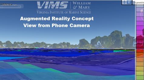
Perhaps one of their most innovative ideas is using “augmented reality” to help residents visualize the extent of a past or future flood by linking the app to their phone’s camera. Loftis says this “is a concept that admittedly needs less introduction now with the advent of Pokemon Go©.” With this feature, app users could “see” the extent of virtual floodwaters in their yard, street, or neighborhood simply by looking at their phone’s screen—all while standing on dry ground.
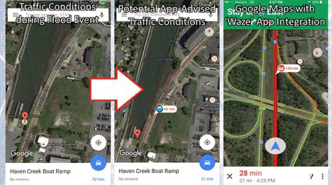
Other ideas include giving users the ability to receive traffic alerts through integration with the Waze App© when forecasts call for flooded streets, and automatic rerouting when coupled with Google Maps©. Similar tools could give emergency managers the geospatial information needed to route emergency vehicles, issue evacuation orders, or take other proactive measures.
Another idea—key to the increased usefulness of many of the app’s other features—is to populate the app with flood forecasts via VIMS’ StormSense project. This project features a state-of-the-art model, developed during the last several years by Wang and colleagues at VIMS, that uses 3-D simulation techniques to integrate winds, waves, seafloor contours, surface friction, and a host of other parameters to predict the extent of floodwaters at the level of individual streets and buildings.
In areas where StormSense predictions are currently unavailable, Loftis and Spencer propose augmenting the SLR App© by incorporating flood-map layers already developed by the City of Norfolk, NOAA, and Climate Central.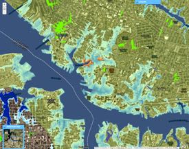
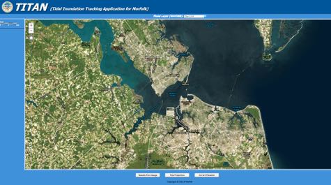
Norfolk’s flood-map product, named TITAN for “Tidal Inundation Tracking Application for Norfolk,” shows water levels throughout the city based on observations at NOAA’s official tide gauge at Sewells Point near Naval Station Norfolk. The pair would enhance the TITAN display by incorporating high-resolution digital elevations derived from LIDAR and connectivity to local storm-water drainage systems.
Business Plan
Because the ultimate goal of the Market Bridge Challenge is to help government staff and contractors in Hampton Roads expand products into commercial markets, Loftis and Spencer’s winning submission also included a business plan that outlines how the SLR App© could be made to pay for itself moving forward. Here they took a page from other successful commercial apps, where users support a free basic version by paying a fee for selected add-ons.
“We think we can make the app sustainable or even profitable by charging a small fee for some premium features,” says Loftis. “While the app would remain free to download with most services available, income from a handful of premium services could accommodate maintenance and future improvements.” They envision that individual premium features would range in cost from $0.99 to $2.99.
Loftis and Spencer put the timetable for software developers to incorporate all their concepts into a working app at months to a few years, depending on funding.