VIMS

'Catch the King' Tide

Let's map how far it floods...

Catch the King is the world's largest environmental survey. It leverages citizen science to aid in GPS flood data collection throughout coastal Virginia. Catch the King aims to map the king tide's maximum inundation extents with the goal of validating and improving predictive models for future forecasting of increasingly pervasive "nuisance" flooding. The project's current focus is centered on mapping inundation extents in coastal Virginia, within the automated mapping scope of VIMS' Tidewatch storm tide forecast map, but we welcome volunteers from outside of our present focus region who are willing and eager to contribute to this endeavor. Please sign up below!

  1. Volunteer Registration (so we can attempt to organize your flood mapping efforts):
    http://kingtide.whro.org | https://facebook.com/groups/435962326798729
  2. Mobile App Registration (free on iOS & Android; use your phone's GPS to map floods):
    https://tinyurl.com/SLRiOS | https://tinyurl.com/SLRAnd 
  3. VIMS' Inundation Model Forecasts (help validate & improve future flood forecasts in VA):
    http://AdaptVA.org/info/forecasts.html (AdaptVA.org features VIMS' short- and long-term flood forecasts, and is run by the CCRM's open-source SCHISM Hydrodynamic Model)

{{youtube:medium|CTZKK1jM2i8, See Catch the King's Recent Media Coverage on CBS This Morning.}}

This year's Catch the King event will focus on the highest predicted astronomical tide of 2019, the king tide, taking place on the morning of Sunday, October 27. This will serve as the annually scheduled dress-rehearsal for a coordinated volunteer network to learn how to map the flood extent of an inundation event using the GPS on their mobile device in preparation for more significant floods caused by hurricanes, nor'easters, heavy rainfall, and wind tides.


Did you hear about Catch the King on CBS This Morning?

Looking to get involved and don't live in Virginia? Check out our video tutorial and PDF walkthrough to learn how to map flooding in a community near you! 

Each year, prior to the king tide flood event, Dr. Loftis at the CCRFR designs a webmap to direct volunteers to public places that are forecasted to flood during the king tide using VIMS' hydrodynamic models. Then, during the king tide, GPS data points are collected by many volunteers to effectively breadcrumb/trace the high water line. This approach is used each year to map flooding extents across coastal cities and counties in Virginia by pressing the 'Save Data' button in the 'Sea Level Rise' mobile application every few steps along the water's edge during annual king tides and after major storm events.

{{youtube:medium|3J9VtXM7hBQ, Learn how Dr. Derek Loftis uses data collected by volunteers during Catch the King events to validate VIMS' street-level flood model.}}

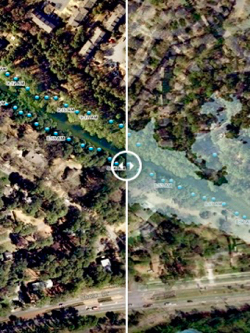
Catch the King's greater scientific aspiration involves using this information to validate VIMS' inundation models via calculated distance differences as demonstrated in the embedded video example below, and by inferred volume differentials, when GPS flood extent data are translated to lidar-derived digital elevation models. Citizen scientists' data are then used to correct elevations and hone spatially varying friction parameterization assumptions in VIMS' models to improve future inundation predictions. 

Click the photo for an example of how Catch the King data has helped improve the VIMS flood model.

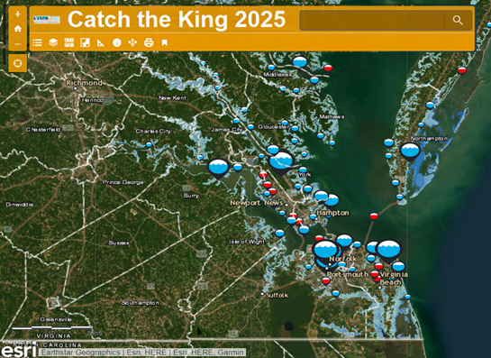
Map of Past Catch the King Flood Monitoring Data
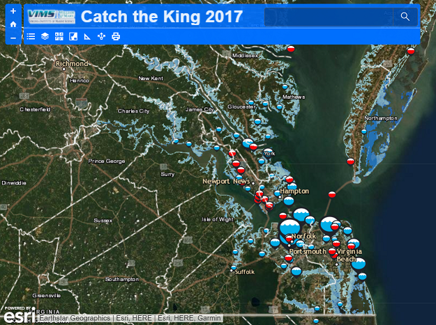
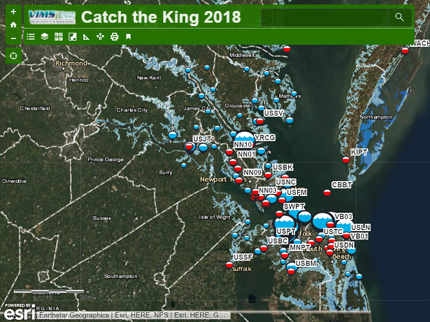
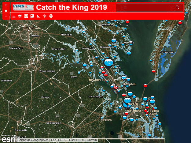
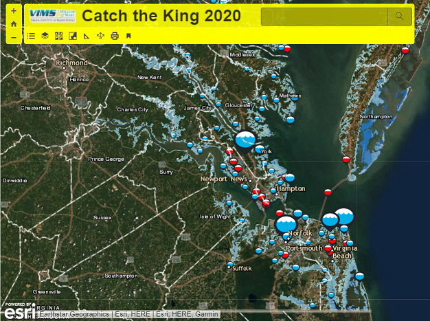
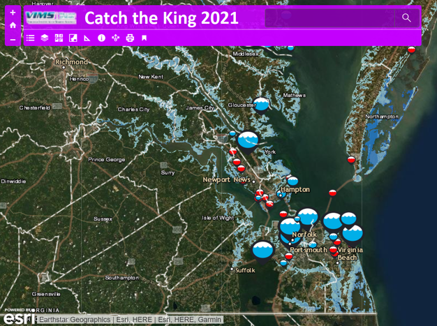
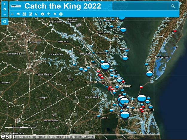
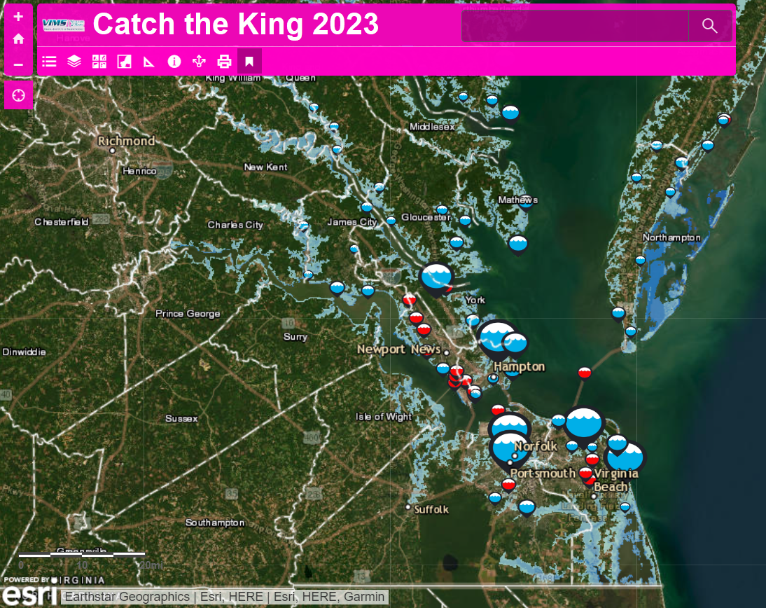
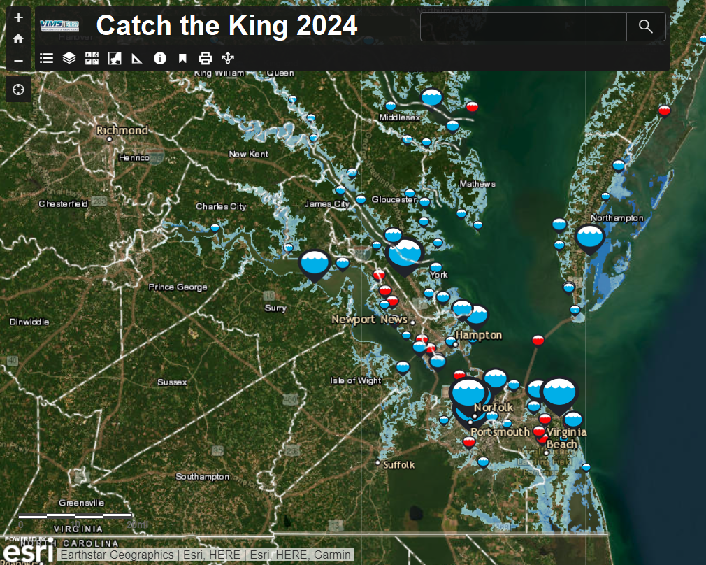
GPS high water mark data from Catch the King 2017 SLRiconforArcGIS and 2018 SLRiconforArcGISgreen.png appear on the embedded map below as aggregated colored dots to mark where volunteers have collected data during past king tide mapping events. This map is useful to illustrate mapping locations observed from past mapping events and to identify areas where there are gaps in previous years' observation efforts. Zoom in on the map to separate the aggregated points at each mapping site. If you wish to access these GPS data as GIS shape files, they are available for download at these pages:

Catch the King 2017
Catch the King 2018


View Full Screen Map in New Window

Response from Catch the King's dedicated volunteers in 2017, fueled by constant media coverage leading up to the event, caused Catch the King to become the largest citizen science/crowdsourcing survey event in the world. Over 35 separate volunteer training events were held all over Hampton Roads resulting in 510 known participants collecting 53,006 time-stamped GPS maximum flooding extent measurements and 1,126 geotagged photographs of the king tide flooding during the 4-hour event. Click here for a map with an illustrative visual distribution of these statistics.


Did you hear about Catch the King on NPR's Science Friday?

Looking to get involved and don't live in Virginia? Check out our video tutorial and PDF walkthrough to learn how to map flooding in a community near you! 

WHRO Public Media, the lead media sponsor for Catch the King, is stepping up promotion of the event as part of a year-round environmental education program for high school students. With a grant from the Hampton Roads Community Foundation and additional funding from the Batten Environmental Education Initiative, WHRO offers incentives to dozens of schools to join in its resilience education effort. Catch the King enables students to share in a project-based outdoor learning experience, utilizing smartphones in a way that’s educational and positive while contributing to a better understanding of the most central of challenges to Hampton Roads: sea level rise. Though this year’s focus will be on attracting more students, Catch the King organizers welcome all individuals and organizations to participate. Catch the King is grateful for the support of tHRive, the young professionals of the Hampton Roads Chamber. This year’s Catch the King also welcomes the sponsorship of the Hampton Roads Sanitation District.

Catch the King is also made possible by the nonprofit groups, Wetlands Watch and Concursive Corp., creators and developers of the citizen-science Sea Level Rise app (iOS and Androidused in the event. Our science liaison is Dr. Derek Loftis of the Virginia Institute of Marine Science, whose work is funded in part by the Commonwealth Center for Recurrent Flooding Resiliency. Our volunteer coordinator is Qaren Jacklich. The dynamic story map below was developed in to recruit the event's many volunteers in 2018 and 2019

Dynamic Story Map


Please allow, when prompted, cookies or scripts to load in order for this dynamic content to display correctly on your screen. Alternatively: View Full Story Map in New Window


The 2017 Volunteer Recruitment Story Map was viewed >10,000 times prior to the king tide due to the gracious media support and coverage articles below along with help from our dedicated volunteers.

Data Archive

View all data Catch the King has collected through the Sea Level Rise App (by year)

Catalogue of Media Coverage of Catch the King:

2019
  1. Pollutants in Flood Waters
    Chesapeake Research Consortium, Feb 11, 2019
    http://chesapeake.org/2019/02/11/pollutants-in-flood-waters/ 
  2. As High-Tide Flooding Worsens, More Pollution Is Washing to the Sea
    Jim Morrison, Yale Environment 360, March 14, 2019
    https://e360.yale.edu/features/as-high-tide-flooding-worsens-more-pollution-is-washing-to-the-sea
  3. Catch the King... the largest environmental survey on the planet
    Dave Mayfield and Derek Loftis, Catch the King, Tides that Bind, & VIMS, April 25, 2019
    https://www.vims.edu/kingtide/world-record/index.php 
    https://www.vims.edu/kingtide/world-record/guinness-news-release.pdf 
  4. Catch the King sets an official Guinness world record
    Tamara Dietrich, Daily Press, April 25, 2019
    https://www.dailypress.com/news/science/dp-nws-catch-king-guinness-20190425-story.html
  5. Catch the King Catches Guinness World Record
    David Mayfield, April 25, 2019
    https://www.vims.edu/newsandevents/topstories/2019/ctk_guinness.php
  6. Catch the King sets an official Guinness world record
    Tamara Dietrich, The Virginian-Pilot, April 25, 2019
    https://pilotonline.com/news/local/environment/article_fa678b56-6778-11e9-bab5-5b26fac7a2fb.html
  7. Catch the King Enters Guinness Record Books!
    Skip Stiles, April 25, 2019
    http://wetlandswatch.org/directors-blog
  8. Catch the King catches Guinness World Record
    Virginia Gazette, April 25, 2019
    https://www.vagazette.com/news/va-vg-wm-digest-0501-story.html
  9. Hampton Roads Now Holds King Tide Guinness World Record
    Chesapeake Bay Magazine, April 26, 2019
    https://www.chesapeakebaymagazine.com/baybulletin/2019/4/26/hampton-roads-now-holds-king-tide-guinness-world-record
  10. Catch the King Catches Guinness World Record
    David Malmquist, College of William & Mary, April 29, 2019
    https://www.wm.edu/news/stories/2019/catch-the-king-catches-guinness-world-record.php
  11. Catch the King Earns a Guinness World Record
    Belinda Elliott, WHRO Public Media, April 30, 2019
    https://whro.org/community/3005-catch-the-king-earns-a-guinness-world-record
  12. From Our Sponsors - Spring 2019
    Virginia Master Naturalists, May 2, 2019
    http://www.virginiamasternaturalist.org/home/from-our-sponsors-spring-2019
  13. Embracing The Salt And Adapting To Sea Level Rise
    Ira Flatow, NPR Science Friday, May 17, 2019
    https://www.sciencefriday.com/segments/embracing-the-salt-and-adapting-to-sea-level-rise/
  14. Citizen-scientists set to Catch the King again this weekend
    Tamara Dietrich, Daily Press, October 25, 2019
    https://www.dailypress.com/news/dp-nw-catch-the-king-20191025-lprxu6jx4rahbiqejvwnmzpgjy-story.html
  15. King tide provides royal value
    David Malmquist, VIMS, October 29, 2019
    https://www.vims.edu/newsandevents/topstories/2019/ctk_2019.php
  16. Catch the King racks up king tide data for a third year
    Tamara Dietrich, Daily Press, October 29, 2019

    https://www.dailypress.com/news/dp-nw-catch-the-king-folo-20191029-fzwv44w7ujdozptjjvd5s6blim-story.html 

    More to come...
    See an article that should be included in this list? Please email it to me at jdloftis@vims.edu.
2018
  1. King Tide data shows Peninsula flooding in 50 years
    Tamara Dietrich, Daily Press, Jan. 23, 2018
    http://www.dailypress.com/news/science/dp-nws-king-tide-folo-20180109-story.html 
  2. How Virginia Beach involves citizens in disaster preparedness
    Nurfilzah Rohaidi, Gov Insider, Feb. 1, 2018
    https://govinsider.asia/smart-gov/sridhar-katragadda-city-of-virginia-beach-stormsense/ 
  3. Podcast: King Tide (Segment: 28:00 - 46:30): 
    Cathy Lewis, WHRO, HearSay with Cathy Lewis, Feb. 1, 2018
    http://www.hearsay.org/2018/02/01/default.aspx
  4. Are You Ready to “Catch the King?”
    Madeline Carey, WHRO, Aug. 1, 2018
    https://whro.org/kids-family/1797-are-you-ready-to-catch-the-king
  5. Hampton Roads is invited to 'Catch the King' ... again
    Tamara Dietrich, Daily Press, Aug. 31, 2018
    http://www.dailypress.com/news/science/dp-nws-evg-catch-the-king-sequel-20180822-story.html 
  6. Reck on the Road: Catch The King
    Chris Reckling, WAVY TV10, Norfolk, Sep. 25, 2018
    https://www.wavy.com/hr-show/reck-on-the-road/reck-on-the-road-catch-the-king/1473776503 
  7. Hampton Roads is invited to 'Catch the King' ... again
    The Virginian-Pilot Editorial Board, Sep. 28, 2018
    https://pilotonline.com/opinion/editorial/article_4ebf740e-c290-11e8-87ed-e388736e774b.html 
  8. Help 'Catch the King' and join a regional effort to measure astronomical tide
    City of Hampton Civic Alert, Oct. 5, 2018
    https://hampton.gov/CivicAlerts.aspx?AID=3583 
  9. Hundreds to help map flooding at this year's Catch the King event

    https://pilotonline.com/news/local/environment/article_e3cfa4ba-ca3d-11e8-b97b-6f0ea90a39c8.html 
  10. Student installs tide gauges in Hampton for citizen scientists to help create 3D flood map
    Tamara Dietrich, Daily Press, Oct. 26, 2018
    https://www.dailypress.com/news/science/dp-nws-catch-king-advance-20181022-story.html
  11. It's time to Catch the King tide again
    Tamara Dietrich, , Oct. 26, 2018
    https://pilotonline.com/news/local/environment/article_d3fe3232-d62b-11e8-9b08-974c014a841e.html
  12. Citizen scientists throughout Hampton Roads turn out to Catch the King

    https://pilotonline.com/news/local/environment/article_0996d966-d62d-11e8-97f8-57998e196619.html
  13. Volunteers map the King Tide in Norfolk
    Steven Graves, WVEC, Oct. 27, 2017
    https://www.13newsnow.com/video/news/volunteers-map-the-king-tide-in-norfolk/291-8295375?fbclid=IwAR2yIvw237KMx42B2QYapdHqx40yTBli-iX9KhxPdcXDRTJHgfBNxBjg5gY
  14. Mapping the King Tide
    Gloucester Mathews Gazette-Journal, Oct. 31, 2018
    https://www.gazettejournal.net/index.php/news/news_article/mapping_the_king_tide
2017
  1. Catch the King: A King Tide Mapping Event, November 2017
    Dave Mayfield, The Virginian-Pilot, and Derek Loftis, Commonwealth Center for Recurrent Flooding Resiliency, VIMS, W&M, Aug. 6, 2017
    http://arcg.is/1f8W1q 
  2. Regional Flood Mapping Event Uses "Sea Level Rise" Phone App
    Skip Stiles, Wetlands Watch, Aug. 10, 2017
    http://wetlandswatch.org/directors-blog/2017/8/10/regional-king-tide-mapping-work-uses-our-phone-app 
  3. "Catch the King" Tide Monitoring Event
    Lizz Gunnufsen, City of Chesapeake, Aug. 29, 2017
    https://nextdoor.com/agency-post/va/chesapeake/city-of-chesapeake/catch-the-king-tide-monitoring-event-62001701/ 
  4. “How are we going to pay for this?” agencies ask re: climate change costs?
    Wes Siler, Rapid Shift, Sep. 11, 2017
    http://www.rapidshift.net/how-are-we-going-to-pay-for-this-agencies-ask-re-climate-change-costs/
  5. Hampton Roads media, scientists are teaming up to understand tides. We need your help.
    Daily Press & The Virginian-Pilot, Sep. 14, 2017
    http://www.dailypress.com/news/science/dp-nws-king-tide-introduction-20170914-story.html
  6. An astronomical high tide will hit Hampton Roads on Nov. 5 -- will you help us Catch the King tide?
    Dave Mayfield, The Virginian-Pilot, Sep. 14, 2017
    https://pilotonline.com/news/local/environment/hampton-roads-media-organizations-are-teaming-up-to-understand-tides/article_e8eb4963-4a78-5270-b2f4-bb2a4378a1f4.html
  7. A few questions and answers about Catch the King
    Dave Mayfield, The Virginian-Pilot, Sep. 14, 2017
    https://pilotonline.com/news/local/environment/a-few-questions-and-answers-about-catch-the-king/article_80c473d2-87b3-509b-b301-9fca31c06a70.html 
  8. VIMS Contributes to ‘King Tide’ Mapping Project
    David Malmquist, VIMS, Sep. 17, 2017
    http://www.vims.edu/newsandevents/topstories/2017/king_tide.php 
  9. Will You "Catch the King"?
    Nicole Alvarado, Military News, Sep. 17, 2017
    http://www.militarynews.com/life/events/will-you-catch-the-king/article_332bb7fc-9bbd-11e7-8c6d-0b77d232bd7c.html 
  10. 'King Tide' mapping project
    David Malmquist, VIMS, Science Daily, Sep. 18, 2017
    https://www.sciencedaily.com/releases/2017/09/170918142147.htm 
  11. Scientists Seek Citizen Help to Map Nov. 5 King Tide Sea Levels
    Laurie L. Dove, How Stuff Works, Sep. 25, 2017
    https://science.howstuffworks.com/environmental/green-science/citizen-science-king-tide-sea-level-11-2017.htm 
  12. Learn how to 'Catch the King' Tide
    Kate Mishkin, Daily Press, Sep. 26, 2017
    http://www.dailypress.com/news/dp-nws-king-tide-preview-20170926-story.html
  13. Catch the King Tide in Hampton Roads
    Belinda Elliott, WHRO Education, Sep. 26, 2017
    http://whro.org/station-initiatives/whro-education/56196-catch-the-king-tide-in-hampton-roads 
  14. Volunteers Learn Tips, Tricks to Measure King Tide
    Kate Mishkin, Daily Press, Sep. 28, 2017
    http://www.dailypress.com/news/science/dp-nws-king-tide-0929-story.html 
  15. Calling All Hampton Roads Residents to Help Catch the King Tide
    Daniel Kvaternik, City of Newport News, Sep. 29, 2017 
    https://www.nngov.com/Blog.aspx?IID=1256 
  16. New App to Document King Tide Flooding in Hampton Roads
    Chesapeake Bay Magazine, Oct. 2, 2017
    https://www.chesapeakebaymagazine.com/baybulletin/2017/9/28/ml6ukn30uffnrusqs71c04f1jpdmcg 
  17. What is the King Tide? Hampton Roads' highest astronomical tide of the year!
    Yasmeen Freightman, WVEC, Oct. 11, 2017
    http://www.13newsnow.com/news/local/king-tide/470643018
  18. Catching the King Tide in Hampton Roads
    The Virginian-Pilot Editorial Board, Oct. 15, 2017
  19. Why King Tides Are Flooding Coastal Cities More Often
    John Perritano, HowStuffWorks.com, Oct. 17, 2017
    https://science.howstuffworks.com/nature/natural-disasters/why-king-tides-are-flooding-coastal-cities-more-often.htm
     
  20. Four newsrooms, 350 volunteers ready to engage Virginians on sea's rise
    Ashley McBride, Poynter, Oct. 17, 2017
    https://www.poynter.org/news/four-newsrooms-350-volunteers-ready-engage-virginians-seas-rise
  21. King Tide volunteer sign-up ends Sunday
    Tamara Dietrich, Daily Press, Oct. 20, 2017
    http://www.dailypress.com/news/science/dp-nws-king-tide-signup-20171020-story.html 
  22. Help Document Sea Level During King Tide Event Nov 4-6
    Jacques Cousteau National Estuarine Research Reserve, Oct. 22, 2017
    http://www.ahherald.com/newsbrief/local-news/24762-help-document-sea-level-during-king-tide-event-nov-4-6 
  23. King Tide: Help scientists 'Catch the King'
    Arrianee LeBeau, WVEC, Oct. 30, 2017
    http://www.13newsnow.com/weather/king-tide-help-scientists-catch-the-king/487222892
     
  24. King Tide offers York County school real-world teaching opportunity
    Josh Reyes, Daily Press, Nov. 1, 2017
    http://www.dailypress.com/news/york-county/dp-nws-york-county-yorktown-elementary-king-tide-20171029-story.html 
  25. Mild weather, flooded streets: Ideal conditions to Catch the King
    Dave Mayfield, The Virginian-Pilot, Nov. 3, 2017
    https://pilotonline.com/news/local/environment/mild-weather-flooded-streets-ideal-conditions-to-catch-the-king/article_21dbdf05-da11-5762-9cc4-ec385cedeb2d.html 
  26. Hundreds of volunteers turn out to Catch the King tide
    Dave Mayfield, The Virginian-Pilot, Nov. 5, 2017
    https://pilotonline.com/news/local/environment/hundreds-of-volunteers-turn-out-to-catch-the-king-tide/article_14364a12-985c-53ef-b675-872e35f1c954.html 
  27. Peninsula volunteers catch the king tide
    Tamara Dietrich, Daily Press, Nov. 5, 2017
    http://www.dailypress.com/news/science/dp-nws-catch-the-king-coverage-20171030-story.html 
  28. Four things we learned from tracing the king tide across Hampton Roads
    Dave Mayfield, The Virginian-Pilot, Nov. 7, 2017
    https://pilotonline.com/news/local/environment/things-we-learned-from-tracing-the-king-tide-across-hampton/article_81e82d0d-b6d6-53c7-a1da-a94b51305e07.html 
  29. An App and Volunteer Army Are Improving Local Tidal Flood Forecasts
    Jessica Leber, News Deeply, Dec. 1, 2017
    https://www.newsdeeply.com/oceans/community/2017/12/01/an-app-and-volunteer-army-are-improving-local-tidal-flood-forecasts
  30. An App is Improving Local Tidal Flood Forecasts
    Ocean Leadership, Dec. 8, 2017
    http://oceanleadership.org/app-volunteer-army-improving-local-tidal-flood-forecasts/ 
  31. Reporters, Scientists, and Citizens Team to Map Virginia’s Highest Tide
    Dawn Wright, ESRI Blog, Dec. 13, 2017
    https://www.esri.com/about/newsroom/blog/mapping-virginias-highest-tide/