Virginia Flood Risk Information System
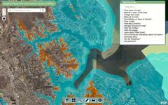
Welcome to the Virginia Flood Risk Information System (VFRIS), a collaborative effort between the Virginia Department of Conservation and Recreation and the Center for Coastal Resources Management at VIMS. The VFRIS helps communities, real estate agents, property buyers, and property owners understand an area's flood risk. By pulling together information from the Federal Emergency Management Agency (FEMA), Fish and Wildlife Service (FWS), and Esri (GIS mapping software), the VFRIS allows users to quickly locate a property to see if it is within the Special Flood Hazard Area (SFHA).
Knowing the location of flood zones helps property owners and buyers understand their flood insurance rate and consider floodproofing options; assists insurance agents in assessing rates; offers builders insight on potential building restrictions and standards; and allows communities to plan where growth should be focused.
The maps displayed on the VFRIS have several different FEMA Zones.
FEMA Zones: (area, description, zone)
Regulatory FloodwayThe channel of a river or other watercourse and the adjacent land areas that must be reserved in order to discharge the base flood without cumulatively increasing the water surface elevation more than a designated height. Within Zone AE |
Special Flood Hazard Area (SFHA)The area that will be inundated by the flood event having a 1-percent chance of being equaled or exceeded in any given year. This area is also referred to as a 100-year floodplain. All A and V zones (Zone A, Zone AO, Zone AH, Zones A1-A30, Zone AE, Zone A99, Zone AR, Zone AR/AE, Zone AR/AO, Zone AR/A1-A30, Zone AR/A, Zone V, Zone VE, and Zones V1-V30) |
Area of Moderate Flood HazardThe area between the limits of the 1 percent flood and the 0.2 percent of being equaled or exceeded in any given year. This area is also referred to as a 500-year floodplain. X (shaded) and Zone B |
Area of Minimal Flood HazardThe area is outside the SFHA and higher than the elevation of the 0.2 percent annual-chance flood. Zone X (unshaded) and Zone C |
Area of Undetermined Flood HazardThe area with a possible, but undetermined flood risk, as no analysis of flood hazards has been conducted. Zone D |
Area of Reduced Risk Due to Levee
The area protected by a levee, reducing the flood risk, so long as the levee is properly maintained. Zone X with reduced risk due to levee |
Coastal Barrier Resources Act (CBRA) Zones:
- Coastal Barrier Resource System units - Relatively undeveloped lands, generally privately held, intended to follow geomorphic, development, or cultural features
- Otherwise Protected Areas - Generally comprised of lands held by a qualified organization primarily for wildlife refuge, sanctuary, recreational, or natural resource conservation purposes
A property may experience flooding even if it is outside of the SFHA or moderate flood hazard area.
Local governments have authority over development within flood zones in their jurisdiction. If your property is in a SFHA, please contact your local officials for information on construction requirements. Before purchasing a property in or near the SFHA, please consider the cost of flood insurance and plan accordingly.
Please go to Virginia Floodplain Management Program to learn more about the state's floodplain management program.