Shoreline Management Model – VIRGINIA
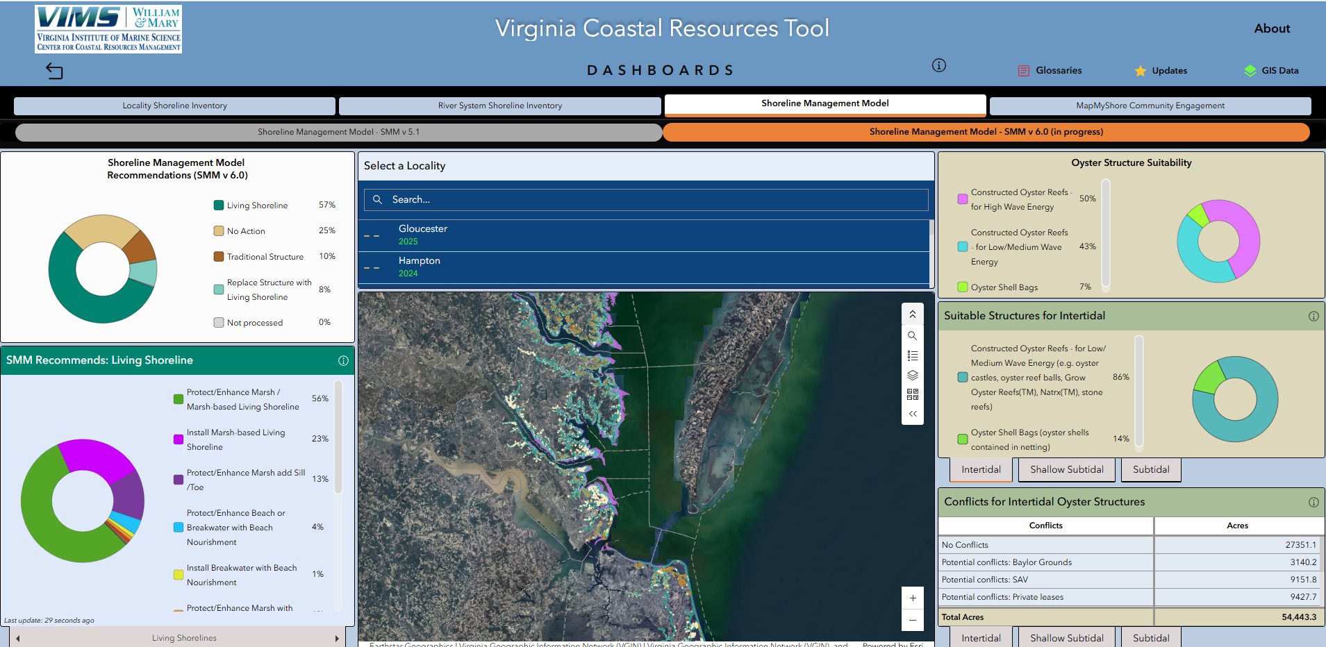
The Shoreline Management Model (SMM) has been upgraded to Version 6.0 (2025) to incorporate newly available datasets and reflect the latest advancements in the science and practice of coastal management. This update enhances the model’s ability to provide more refined and comprehensive shoreline management recommendations across a broader range of conditions. The Virginia Institute of Marine Science is currently applying SMM v6.0 across Virginia’s coastal localities.
During this transition period, SMM Version 5.1 (2019) will continue to be displayed for localities where the updated model has not yet been implemented. As SMM v6.0 is progressively applied statewide, users will see updated recommendations reflecting the improved model framework.
Model recommendations can be visualized through the Virginia Coastal Resources Tool, providing an interactive platform to explore shoreline management strategies.
SMM Version 6.0 (2025) – NEW!
SMM Version 6.0 – Glossary of Model Recommendations
SMM Version 6.0 – Visualization of Model Recommendations
SMM Version 6.0 – Shoreline Best Management Practice Classifications:
Living Shoreline
|
Replace Structure with Living Shoreline
|
Special Considerations
|
Traditional
|
Oyster Structures Suitability Module Outputs
|
No Action
|
SMM Version 5.1 (2019)
NOTE – This version of the model is currently being retired, and the model recommendations for Virginia localities are currently being updated with Version 6.0
SMM Version 5.1 – Glossary of Model Recommendations
SMM Version 5.1 – Visualization of Model Recommendations
SMM Version 5.1 – Shoreline Best Management Practice Classifications
|
Special Considerations
|
These data should be used to guide the decision-making process for how best to manage an erosion problem. Recommendations are made without consideration of property length, ownership, or value. Treatment recommendations are based on models that utilize the best available data, which may not reflect the actual conditions present on the shoreline.
Related Links
- Nunez, K., Mason, P., Rudnicky, T., Tombleson, C., Duning, C., Hendricks, J., Lv, M., Hill, E., Graulich, J., Schatt, D., & Duhring, K. (2026). Advancing the use of spatial data in implementing adaptive management to support coastal resilience. In C. Coelho, C. Hallin, F. Sancho, & P. A. Silva (Eds.), Coastal Dynamics 2025 (Vol. 1, pp. 284–290). Springer. https://doi.org/10.1007/978-3-032-15473-6_45
- Nunez, K., Rudnicky, T., Mason, P., Tombleson, C., Berman, M. (2022). A geospatial modeling approach to assess site suitability of living shorelines and emphasize best shoreline management practices. Special Issue: Nature-based coastal defense: developing
- Tidal Shoreline Inventories shoreline conditions map used for model input
This model has been funded, in part, and at various stages, by the VIMS' Center for Coastal Resources Management, the NOAA RESTORE Science Program, and NOAA's Coastal Zone Management Program in Virginia.