Facilities & Equipment
In addition to a variety of lab and field facilities that integrate into the broader VIMS Coastal & Ocean Processes Section, the Coastal Geology group proudly stewards a suite of laboratory spaces and specialized analyzers of sedimentological properties.
Laboratory Spaces
Core Repository
The VIMS Sediment Core Repository houses hundreds of sediment cores and individual samples of local and global origin in a climate-controlled sediment samples, both for active research use and long-term storage. Efforts are currently underway to compile a complete list of repository samples and metadata into a publicly-accessible database, so that our sample collection can aid future generations of geoscientists. Please reach out to the Laboratory Manager regarding inquiries about our current sample inventory.
Particle-Size Analysis Lab
This lab is equipped with multiple instruments for measuring grain-size, geometry, and other geotechnical properties of unconsolidated sediments. This equipment is available upon request for use by VIMS students and employees (training required). We also perform laboratory analytical services to internal and external customers. Check out our Sedimentology & Gamma Lab Cost Center page for pricing and additional details.
Core Processing and Photography Lab
Our core processing lab houses specialized equipment for splitting sediment cores, capturing high-resolution photography of surface color and texture, and writing visual core descriptions. This equipment is available upon request for use by VIMS students and employees, and we also can perform core processing services for VIMS internal and external customers.
Geochronology Lab
This lab space currently houses three Low Energy Germanium (LEGe) gamma detectors and one Broad Energy Germanium (BEGe) gamma detectors for analyzing short-lived radioisotopes, like Pb-210 and Cs-137, primarily for sediment geochronology. The Gamma Lab operates as a cost center to perform analytical services for VIMS internal and external customers. More information about radioisotope geochronology lab services can be found here.
Gas Chromatography Lab
Relocated to new Chesapeake Bay Hall in 2025, this lab serves in the isolation, purification and combustion of individual organic compounds for compound-specific radiocarbon analysis. The space houses a GERSTEL Gas Chromatograph with a Preparative Fraction Collector (a “Prep GC”), dedicated low-blank vacuum line, and a laminar-flow hood. Although not the type of lab typically affiliated with coastal sedimentologists, this lab is one of a small handful in academic settings in the world and allows us to apply the cutting-edge tools of compound-specific organic geochemistry to understand the linkages between climate and coastal change.
Sample Collection Equipment
Geoprobe Direct-Push Drill Rig
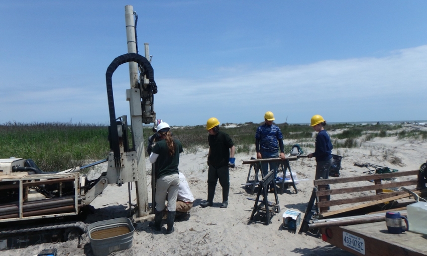
Our Geoprobe 66DT drilling rig can maneuver over soft sand and shallow water, making it ideal for collecting sediment cores from coastal barriers and beaches. Equipped with powerful hydraulics and percussion, this rig easily collects sediment cores to depths of 30m (100 feet) on barrier islands and coastal mainlands throughout the US East Coast.
Tripod Vibracore Rig
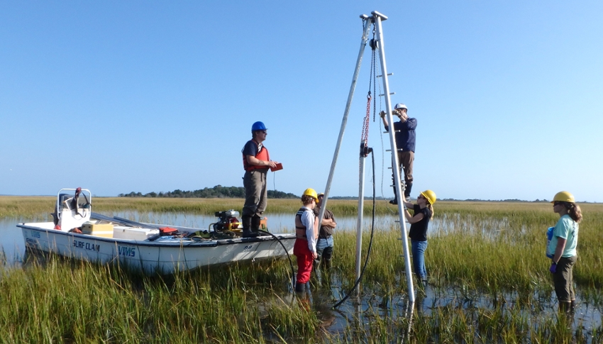
A sturdy and efficient method of coastal sediment coring, our vibracore rig setup works by attaching a concrete vibrator to the top of a 3-inch aluminum tube to penetrate through fine and sandy sediments. The steel tripod structure is highly customizable; this corer can be used in estuaries, beaches, and aboard the R/V Peregrination.
R/V Peregrination
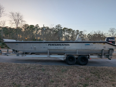 A 30'-long landing craft / coring platform is housed and operated out of the VIMS Eastern Shore Lab. This specially-designed vessel is equipped with a moon hole for collecting through-hull vibracores in water depths of up to 3 m, and is capable of transporting our Geoprobe drill rig to remote coring sites, such as along the Virginia Barrier Islands.
Augers
Our lab is equipped with several different hand augers to compliment our suite of coring rigs. These include a hand-operated Geoprobe slide hammer, a Russian peat corer, a complete Eijkelkamp auger set, and a pulse auger (10 m maximum depth).
Offshore Sediment Samplers
Ekman-style ponar grab samplers and a channel dredge round out our current collection of sediment sampling equipment. These devices are used to capture sample material at the sediment-water interface in coastal and nearshore environments.
Acoustic Scanners
Ground Penetrating Radar (GPR)
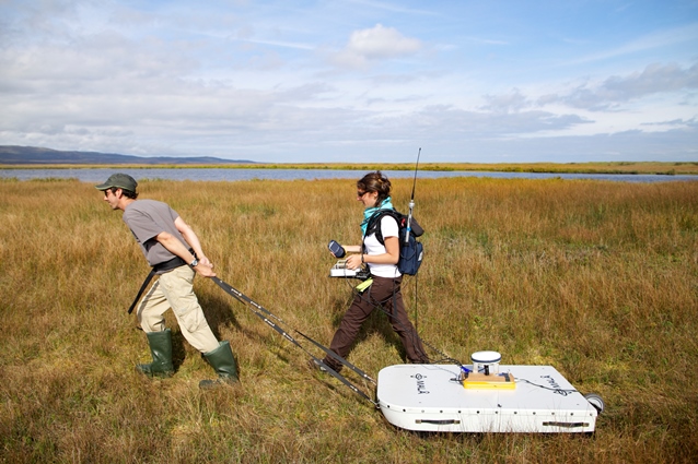
We have both a GSSI SIR-4000 with a 200 MHz hyperstacking antenna and a standard 400 MHz antenna, and a MALÅ Geosciences X3M GPR with 100, 250, 500, and 900 MHz antennas. Together, these are capable of collecting continuous, high-resolution subsurface surveys ranging from cm-scale resolution in the upper 1-2 m, to dm-scale resolution nearly 20 m below the ground surface. A suite of software is available in the Coastal Geology Data Processing Lab for the processing and analysis of these data.
Bathymetry Sonar
In addition to our lab's own portable Odom Echotrac CVM single-beam echosounder, the Coastal Geology group is also the primary user of the R2Sonic Sonic 2026 mounted multibeam echosounder, which allows us to collect ultra-high resolution bathymetry surveys at our coastal and nearshore study sites.