Moore goes with flow to monitor water quality and seagrasses
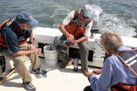
A team of VIMS scientists led by Dr. Ken Moore is using two new high-tech sensors to track Virginia’s commitment to the water-quality standards of “Chesapeake 2000,” the Chesapeake Bay Program’s most recent blueprint for Bay restoration and protection. Restoration of the Bay’s submerged aquatic vegetation, or SAV, is one of the plan’s primary goals.
Moore’s interest in water quality relates to his long-term interest in SAV restoration. The historical decline of these underwater grasses, documented by VIMS researchers using aerial photographs, is largely due to shading by increased levels of sediment, nutrients, and algae in the water.
 Moore’s Dataflow sensor helps identify areas in the James and York rivers where the water is consistently clear enough to support SAV growth at the depths defined in the Chesapeake 2000 plan. This task is difficult if not impossible using present monitoring sites and methods.
“Although water quality is monitored at fixed stations in mid-channel areas of the James,” says Moore, “we don’t have a good understanding of conditions in the shallower areas where seagrasses grow, or how water-quality conditions vary with space and time.”
Dataflow is deployed during monthly cruises from a small boat operating at speeds up to 25 knots. It collects surface water through a pipe on the vessel’s keel, pumps it through an array of water-quality sensors, then discharges it overboard. The sensors record dissolved oxygen, salinity, temperature, turbidity, and chlorophyll—all parameters that relate to water clarity, algal abundance, and seagrass health.
Dataflow collects one sample every 2-4 seconds, which at an average speed of 25 knots provides a data point every 40-60 yards. It sends these data to a laptop computer, along with GPS data on location and depth. VIMS researchers use these data to produce detailed digital maps of water-quality across a study site. State managers are using these maps to evaluate efforts to reduce pollution in coastal waters, and to assess whether existing seagrass beds or designated restoration areas actually experience the conditions needed for seagrass survival.
Moore’s team has used Dataflow to produce surface maps of water quality in the York and James Rivers. Funding for the York River work came from the Virginia Department of Environmental Quality. EPA funded the James River work.
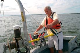 The Acrobat is a torpedo-like vehicle that is towed behind a larger boat. It provides a means to sample water quality in deeper portions of the Bay. Still in its testing phase, Acrobat can be programmed to sample along an undulating course between the surface and deeper waters, thus providing a three-dimensional view of water quality.
Moore and the other collaborators on this project, including Drs. Iris Anderson, Larry Haas, and Howard Kator, are particularly excited about Acrobat’s ability to measure levels of dissolved oxygen in real time. “Deeper regions of the Bay often lack the levels of dissolved oxygen needed to support life,” says Moore. “Acrobat will allow us to map these zones and to understand how they expand and contract in relation to temperature, salinity, and depth.”