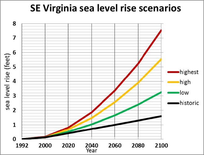
Sea-Level-Rise Scenarios
The VIMS report on recurrent coastal flooding uses 4 scenarios of sea-level rise for planning purposes. The scenarios were developed for the National Climate Assessment and modified for southeastern Virginia by incorporating an estimation of land subsidence in the region. The 4 scenarios represent plausible trajectories for local sea level based on a combination of factors:
- The lowest or “historic” scenario is a projection of observed long-term rates of sea-level rise going back a century or more. It incorporates no acceleration.
- The “low” scenario is based on the IPCC 4th Assessment model using conservative assumptions about future greenhouse gas emission (the B1 scenario).
- The “high” scenario is based on the upper end of projections from semi-empirical models using statistical relationships in global observations of sea level and air temperature.
- The “highest” scenario is based on estimated consequences from global warming combined with the maximum possible contribution from ice-sheet loss and glacial melting (a practical worst-case scenario based on current understanding).
The science team that developed the scenarios for the National Climate Assessment indicated the high scenario should allow assessment of risk from limited ice-sheet loss, while the low scenario represents risk primarily from ocean warming. Recent data suggest that sea-level rise is currently proceeding along the “high” trajectory. For planning purposes the VIMS report recommends anticipation of a 1.5-foot rise in sea level above the 1992 datum within the next 20 to 50 years (2033 - 2063).