

Virginia Oyster Reef Restoration Map Atlas
The Oyster Restoration Atlas was prepared in response to a
request for assistance from the Norfolk District office of the U.S. Army
Corps of Engineers (COE), staff of the Virginia Institute of Marine
Science (VIMS) and Virginia Marine Resources Commission (VMRC) in 2002.
The COE wished to devote efforts to oyster habitat restoration in the
Chesapeake Bay for environmental and water quality improvement. In
tandem, the Chesapeake Bay Program was coordinating the production of
The Baywide Comprehensive Oyster Plan for Maryland and Virginia. VIMS
and VMRC were preparing the Virginia component of this plan
cooperatively. The original map atlas illustrated the potential location
of future oyster reef restoration projects in Virginia waters relative
to those plans.
The current edition (2009) of the Oyster
Restoration Atlas (2009) has added depth and salinity as factors on the
original maps. The original maps were based on maps of oyster habitat in
Virginia made by Lt. Baylor of the U.S. Navy between 1892 and 1896.
This atlas incorporates details describing the most recent substrate
maps, limits of public and leased oyster grounds, bathymetry and
salinity in relation to current and potential restoration sites.
These maps are generated to illustrate the results of the targeting effort following the protocol described in the Restoration Siting Protocol section. The authors recognize this level of targeting does not preclude the need for field inspection at potential sites prior to reef construction. The atlas is comprised of a series of boxes preceded by an index locator (below). The scale of each box may vary. The potential restoration areas are illustrated in red. The legend reports the total acres available for restoration within the boundary of each box.
In addition to the targeted sites, additional GIS data are included to provide assistance in site selection. Illustrated in grey, shellfish condemnation zones represent waterways that have been designated by the Virginia Department of Heath, Division of Shellfish Sanitation as closed for the taking of shellfish. These closures are based on regular fecal coliform monitoring by the Division. The GIS data are a modified version of AutoCAD files developed and maintained by the VMRC survey division.
General bathymetry is provided on the basis of water depths less than 1 m, between 1 and 6 meters, and greater than 6 meters. Salinity data are provided on the basis of greater or less than 10 ppt. Both of these data sets were developed and maintained by the Chesapeake Bay Program and are available through their website.
The location of existing restoration sites is denoted as solid black triangles. Geographic positions for reef sites were collected using Global Positioning Systems (GPS) in the field. These sites represent restoration activities that have occurred in Virginia waters with support from a variety of agencies and organizations. The VMRC has been responsible for overseeing the construction of these sites.
Sentinel monitoring stations are long-term monitoring stations where oyster populations have been recorded over time. Monitoring is being performed by VIMS and VMRC. Sentinel monitoring stations are denoted with a solid black circle. The public oyster ground boundaries are illustrated using a thick black line. The private leases, which are administered by VMRC, are illustrated with a thin black line.
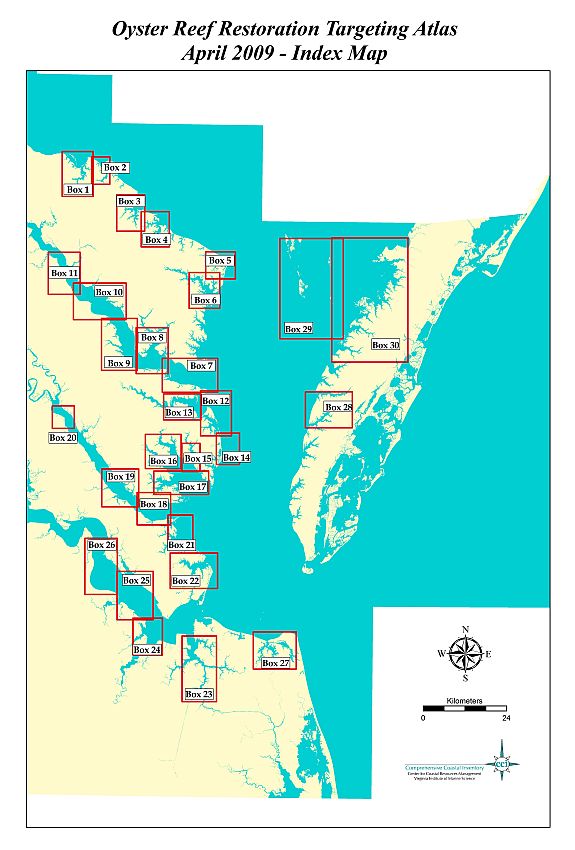
Click on the name of a box to go to the corresponding site map and description.
| Box 1: Nomini Creek | Box 16: North & Ware Rivers |
| Box 2: Lower Machodoc Creek | Box 17: Severn River |
| Box 3: Yeocomico River | Box 18: York River to Gloucester Point |
| Box 4: Glebe and Coan Rivers | Box 19: York: Beaver Dam to Roosevelt Pond |
| Box 5: Little Wicomico River | Box 20: York River - Mattaponi River |
| Box 6: Great Wicomico River | Box 21: Poquoson River |
| Box 7: Mouth of the Rappahannock River | Box 22: Back River |
| Box 8: Rappahannock & Corrotoman Rivers | Box 23: Elizabeth & Lafayette Rivers |
| Box 9: Rappahannock: Punchbowl Pt - Towles Pt | Box 24: James & Nansemond Rivers |
| Box 10: Rappahannock: Wares Wharf- Punchbowl Pt | Box 25: James River |
| Box 11: Rappahannock: Lowerys Pt - Neals Pt | Box 26: James River - Burwell's Bay |
| Box 12: Mouth of Piankatank River & Gwynn's Island | Box 27: Lynnhaven Rivers & Broad Bay |
| Box 13: Piankatank River | Box 28: Nassawadox & Occohannock Creeks |
| Box 14: Chesapeake Bay | Box 29: Tangier Island & Sound |
| Box 15: East River | Box 30: Pocomoke Sound |
Download a copy of the entire Virginia Oyster Reef Restoration Map Atlas as .pdf