

What is NEAMAP?
 F/V Darana R captained by Jimmy Ruhle
 NEAMAP trawl net
 Unloading a large NEAMAP catch
 Basket of fish from a NEAMAP tow
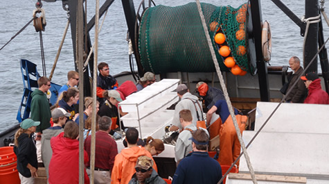 NEAMAP demonstration tow NEAMAP personnel welcome interested parties to participate in short 2-3 hour cruises to experience sampling aboard the F/V Darana R, during the Fall (Sept./Oct.) and Spring (April/May) surveys. Previous demo tows have taken place out of Hampton, VA, Montauk, NY, and Port Judith, RI. If you are interested in participating, please continue to check this page for updated information and contact Jim Gartland at (804) 684-7546, jgartlan@vims.edu, or Chris Bonzek at (804) 684-7291, cfb@vims.edu.
NEAMAP stands for NorthEast Area Monitoring and Assessment Program. NEAMAP was developed to meet the needs of fisheries management and stock assessment activities in the northeastern United States. NEAMAP began in 2006 with a fall pilot survey and in 2008 began conducting both a spring and fall survey. NEAMAP samples from Cape Cod, MA south to Cape Hatteras, NC and targets both juvenile and adult fishes.
NEAMAP is an integrated, cooperative state/federal data collection program. Its mission is to facilitate the collection and dissemination of fishery-independent information obtained in the Northeast for use by state and federal fisheries management agencies, the fishing industry (commercial and recreational), researchers, and others requesting such information. The intent of NEAMAP is not to change existing programs, but to coordinate and standardize procedures and improve data quality and accessibility.