

Cornwallis AUV/ROV Project
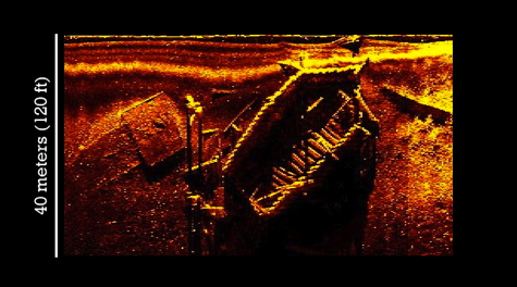 Sidescan Image A side-scan sonar image of one of the newly discovered Yorktown shipwrecks. Photo courtesy of David Niebuhr.
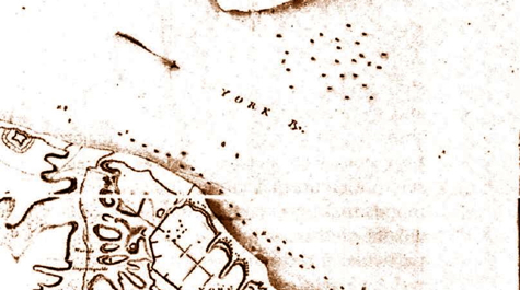 Yorktown, 1781 A historical map of the vessels scuttled by Lord Cornwallis during the siege of Yorktown in October 1781. Photo courtesy of Jamestown-Yorktown Foundation.
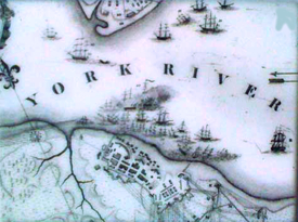
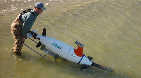 Fetch Launch VIMS graduate student Jarrell Smith launches the submarine robot Fetch into the York River. Photo by David Malmquist.
Underwater robotics applied to STEM education—A time-sensitive discovery in marine archaeology
The Cornwallis project is a partnership between the Virginia Institute of Marine Science’s Autonomous Systems Laboratory, a world-recognized leader in marine robotics, and the Watermen’s Museum, an informal educational facility. Both institutions are in close proximity to a national historical treasure, the fleet scuttled by Lord Cornwallis during the 1781 Battle of Yorktown—the decisive battle of the American Revolution.
This pioneering partnership uses an innovative educational approach that gives school children the opportunity to use underwater robots—both an Autonomous Underwater Vehicle (AUV) and a Remotely Operated Vehicle (ROV)—to monitor the Cornwallis shipwrecks, thereby integrating marine exploration and archeology, marine robotics, and estuarine science to address a monitoring need with national historical significance.
The focus of the project is to develop a methodology that will allow students to experience the full range of events that occur on a real expedition, including mission planning, execution and monitoring, and data analysis. The objectives are to
- design and debug procedures for robotic operation and data collection, analysis, and reporting that are user-friendly for students at several developmental stages of their education,
- develop lesson plans using input from a multidisciplinary team of scientists and engineers, outreach specialists, and K-12 teachers that use data collected by the students using the robots,
- test this unique experience with students, including groups underrepresented in STEM fields, and
- assess the approach to gauge its educational impact.
The data gathered by the students will help inform state and federal entities interested in monitoring the conditions of these wrecks. These entities include the National Park Service, the Virginia Marine Resources Commission, and the National Oceanic and Atmospheric Administration.
The students' 2-to-3 hour mini-expeditions will impart memorable impressions about robotics, marine science, and world history. We expect that “pride of ownership” (through seeing their data end up on the Internet helping monitor and protect such an important treasure) will engage students in a way that leads to a higher probability of pursuing a STEM career.