U.S. Gulf Coast Sea Level
Annual Values & Processes
Trend Values for 2022
Processes
In addition to steric changes, the dominant process affecting sea level along the U.S. Gulf Coast is withdrawal of groundwater and hydrocarbons. Learn more by expanding the dropdowns and visiting our Processes page.
Withdrawal of Groundwater and HydrocarbonsHistorically, subsidence in Louisiana and Texas has been associated with withdrawal of both groundwater and hydrocarbons. Tide-gauge records show continual subsidence in Galveston, TX and Grand Isle, LA between 1950-1990, but with steadily declining subsidence rates following 1970. By 1990, subsidence in both areas appears to have effectively stopped (Kolker et al. 2011). In Grand Isle, subsidence was linked to oil production, which began to decline in the 1970s and was minimal by the 1990s. Subsidence in the Galveston region was due to groundwater withdrawal (Kolker et al. 2011), with Gabrysch and Coplin (1990) reporting extreme subsidence rates of 120 millimeters per year between 1964 and 1973. These rates lowered dramatically following the reduction of groundwater pumping in the early 1970s. However, the early high rates are still captured in the beginning of the sea-level-rise histories presented here. Elevated subsidence rates due to withdrawal of groundwater and hydrocarbons are localized (Morton et al. 2006). Thus our other Texas tide-gauge stations (Rockport and Port Isabel) probably did not experience high levels of subsidence at any point in their history. |
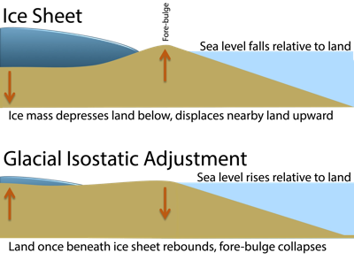
Glacial Isostatic Adjustment (GIA)
The role of glacial isostatic adjustment along the Gulf Coast has not been well defined. Gonzalez and Tornqvist (2006) document a minimal GIA contribution (0.4 millimeter per year) for Pensacola, Florida; modeling by Mitrovica and Milne (2002) suggests that GIA makes a minimal contribution to subsidence along the north central Gulf Coast. |
Ice Sheet Melting (Greenland and Antarctica)Global models suggest that contributions to sea-level rise from melting of the Greenland and Antarctic ice sheets should not vary along the Gulf Coast stations (Kopp et al. 2014). |
Ocean DynamicsGlobal models suggest that ocean dynamics will contribute little to variability in sea-level trends among the Gulf Coast stations (Kopp et al. 2014). |
Other FactorsThe Texas coastline has significant faulting, and periodic shifts occur along these faults (White and Tremblay 1995). The effect of these seismic shifts on tide gauge records has not been examined but could potentially affect acceleration rates. In Galveston, slippage was most active between 1960-1970 (Kolker et al. 2011). In contrast, the tide-gauge station at Pensacola, FL sits on a stable carbonate platform and is considered to be tectonically stable (Gonzalez and Tornqvist 2006), Kolker et al. 2011). Barometric anomalies affect sea levels at Gulf Coast stations. During years when high-pressure weather systems dominate, resulting winds drive water towards the northern Gulf, while in years of low pressure, winds are driven to the south (Kolker et al. 2011). Sediment loading can affect subsidence. Grand Isle, LA has higher rates of sea-level rise than surrounding Gulf Coast stations, which Penland and Ramsey (1990) attribute in part to its thick layer of Holocene sediments deposited by the Mississippi River. This sedimentary wedge is thinner in Texas and completely absent in Florida. |