

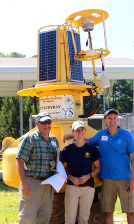
VIMS assists in launch of NOAA buoy
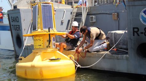 Deployment NOAA technicians deploy the CBIBS buoy into its new position at the York Spit. © C. Katella/VIMS.
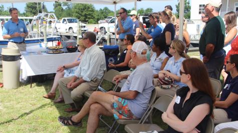 Launch Ceremony Petyon Robertson (L), director of NOAA’s Chesapeake Bay Office, describes the buoy’s importance during remarks at the launch ceremony. © D. Malmquist/VIMS.
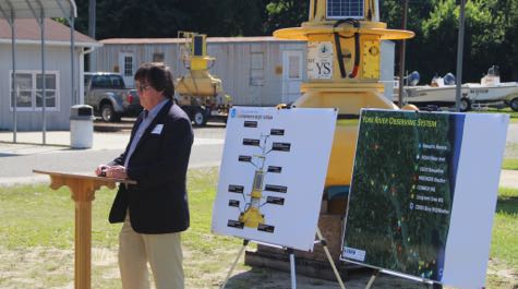 Launch Ceremony Dr. Mark Luckenbach describes how the buoy will benefit from VIMS research and vice versa during remarks at the launch ceremony. © D. Malmquist/VIMS.
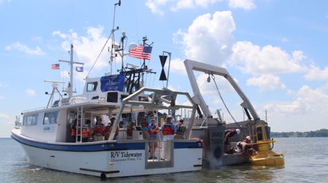 Deployment Dignitaries and stakeholders watch as NOAA technicians deploy the new CBIBS buoy at York Spit. © C. Katella/VIMS.
Data will fill gap in Baywide observing system, enrich York River research
Stakeholders with an interest in monitoring and preserving the health of Chesapeake Bay gathered at the Virginia Institute of Marine Science last week to celebrate the launch of a NOAA data buoy that will help fill a long-standing gap in the Chesapeake Bay Interpretive Buoy System, or CBIBS.
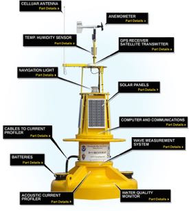
CBIBS, a baywide network of 10 observation buoys that mark points along the Captain John Smith Chesapeake National Historic Trail, merges cell phone and internet technology to record and transmit a wealth of real-time data, including wind speed, water and air temperature, wave height, salinity, dissolved oxygen, turbidity, and chlorophyll levels.
The recently launched buoy is now broadcasting data from its anchorage in 30 feet of water at the mouth of the York River, about 12 miles downstream from the VIMS campus in Gloucester Point. It is expected to see heavy use given its proximity to York River shipping, nearby fishing grounds, and VIMS’ long-standing network of research platforms and field sites. Boaters, anglers, scientists, and other users can access the data via a smart phone app, the web, or by calling toll-free to 877-BUOY-BAY.
Dr. Mark Luckenbach, Associate Dean of Research and Advisory Services at VIMS, said in comments during the launch ceremony that “As the state’s advisor on marine resources, we have a long history of water-quality monitoring and modeling, and the addition of this buoy into that program is going to be really important. We really value our partnerships with NOAA and look forward to continuing them in the future.”
Other participants in the ceremony included Peyton Robertson, Director of NOAA’s Chesapeake Bay Office; Molly Ward, Virginia Secretary of Natural Resources; Dr. William Reay, Director of the Chesapeake Bay National Estuarine Research Reserve program at VIMS; and Charlotte Hurd, Regional Director for U.S. Senator Mark Warner. Also attending were stakeholders from the Chesapeake Bay Foundation, National Park Service, National Weather Service, Nature Conservancy, Peninsula Saltwater Sport Fishing Association, U.S. Coast Guard and Coast Guard Auxiliary, Virginia Marine Resources Commission, and Virginia Sea Grant.
 In his comments, Reay said “Today is a great example of NOAA and the Commonwealth working together to leverage resources and products. What you see here is an example of a local observing system pushing up into a regional system that is pushed into a national system.”
The CBNERR program at VIMS contributes significantly to the local observing system, compiling a network of data buoys, platforms, and programs into a web interface known as the Virginia Estuarine and Coastal Observing System, or VECOS. Managing VECOS is VIMS professor Ken Moore.
VECOS data from the Virginia portion of Chesapeake Bay are then combined with CBIBS data from both Virginia and Maryland. These bay data are further integrated into MARACOOS—the Mid-Atlantic Regional Association Coastal Ocean Observing System, which stretches from Cape Cod to Cape Hatteras—and then into the even broader U.S. Integrated Ocean Observing System. IOOS® is a nationwide network of coastal observatories that stretch from Maine to Alaska and Hawaii, with additional components in the Great Lakes, Caribbean, and U.S. Pacific territories.
Robertson, NOAA CBO chief, focused his comments during the launch ceremony on the important role the new buoy will play in the CBIBS system. “When you’re at a scientific institute like VIMS, the ability to collect real-time data and combine it with data from the York River observing system and the sentinel sites that are in place for looking at climate over time, that’s a real opportunity to fill a hole and get data that will be useful.”
 “When you see all the changes that are going on around the Chesapeake,” he adds, “these buoys are giving us a record of what is happening from here forward—a long-term data set that we can use to track climate and better serve the increase in recreational use of the Bay.”
Secretary Ward described CBIBS and the new buoy as a good example of the Commonwealth’s continuing support of water-quality improvements in Virginia. “The Governor is very focused on water-quality and conservation issues related to Chesapeake Bay,” she said. “He’s currently the chair of the STAC committee for the Chesapeake Bay program at EPA, so this is always on the front of his desk. We're believers, and in this [observing system] full bore. We’re grateful for the data that the buoys provide and their relationship with the Captain John Smith trail.”